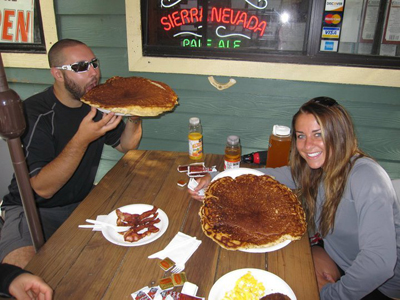
We tried to obtain 8 permits in 2009 for a variety of possible date options that summer, but were denied. Our luck improved this year when we selected a larger variety of dates and reduced our request to just 5 permits. Overnight trips are limited to just sixty new backpackers per night. Hundreds apply for these sixty slots on summer weekends, so we were very fortunate to win them. We started our trip by acclimating for a week doing medium-altitude hikes in Sequoia and Yosemite National Parks. After Yosemite, we headed southeast to the town of Lone Pine. We picked up our permits in the huge Lone Pine Interoffice Ranger Station, which had some of the most friendly and helpful rangers I've ever met. With permits (and wag-bags!) obtained, we headed off to the Whitney Portal campsite to the west of Lone Pine. Things started out a bit hairy for us at this campsite, which we were using the night before we began our hike. It had just gotten dark and we were in the process of putting our backpacks—loaded with all the gear and food we would need for the next three days—into the bear lockers that are provided at each and every campsite. The use of these lockers is absolutely mandatory, but to be honest we were being a little slow-moving about throwing everything in there and locking it up. However, there were always three or four people within 5 or 6 feet of the locker at all times. Just as three of us were finishing packing our bags on a provided picnic table, a big mother black bear, probably 225-250 pounds, snuck right up behind us, slapped her paw inside of the locker, and grabbed one of the fully loaded backpacks. The bear threw the backpack in her mouth with ease and ran off. One member of our group witnessed the entire thing. We knew that we had to get the backpack back before the bear ripped it apart, or our Whitney plans would be all screwed up the following morning. We would have had to return all the way back down to town and spend hundreds of dollars buying new gear. So, we all (foolishly?) started chasing after the bear, assuming that it would never attack the five of us and the three campground neighbors that we quickly recruited to help us. With headlamps and bear-spray in hand, we managed to get the bag back after the bear dropped it beside a stream within the campground. It tried very hard to return back to the bag after it had dropped it, but between the yelling and screaming of the eight of us, it never got within 10 feet of it again. At one point a member of our group unloaded a bit of the bear spray to keep the bear at bay. It was scared of the spray, indicating to us that perhaps it has been sprayed before. During all of this, one member of our group realized that one of the bear’s cubs was a few feet directly above him in a tree. This was a dangerous situation that we were lucky to get completely out of. After we got the bag back and locked up for the night, the bear didn’t return. We learned an important lesson as a result of all this – the bears of the Sierra are extremely smart and aggressive. The bear lockers must be used and locked immediately. These bears are not shy like most of the ones in the East. The next morning we decided that we would carbo-load before our hike by trying some of the famous giant pancakes of the legendary Whitney Portal Store. These pancakes are enormous – at least two times as big as the largest pancakes I had ever seen prior to that (Miss Adams Diner in western Mass). We heard rumors that if you could finish just one of these $6 pancakes, you could get your money refunded. One pancake was easily enough to fully feed 3 people. Portions of their other offerings (hash browns, bacon & ham) were also absurdly sized.
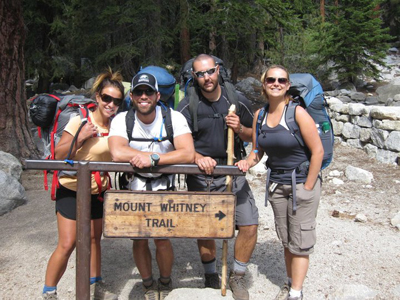
We enjoyed the food offered by the store. The store itself was great as well, with lots of Mt. Whitney information, maps, and memorabilia. The owners were helpful and extremely nice. This store has become part of the tradition of climbing Mt. Whitney, and it fully lives up to its great reputation. We started hiking around 10am, all completely stuffed and feeling rather lethargic. Some of us began thinking that maybe the huge pancakes weren’t the best idea before starting a hike of this magnitude. The weather was perfect though—70 degrees and sunny—and the forecast for the next few days was ideal; warm and light winds with an expected summit temperature of 45 degrees. The trail starts only about 100 feet east of the store.
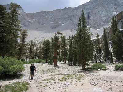
The first 2.5 miles of the hike were half-exposed to the sun. The first footsteps were scenic, but not extraordinarily so. Views of the valley behind you continued to improve as we kept climbing higher and higher on a series of easy switchbacks. There were a few minor stream crossings on this section of trail, but they were easily rock-hoppable.
We entered the Mt. Whitney Zone around mile 2.8. Soon after, we passed a USFS ranger performing trail maintenance (who also took a quick glimpse of each hiker that passed him to make sure that a permit was attached to each backpack).
A short distance further, we reached Outpost Camp at 10,365ft. This is the first “official” camp along the Mt. Whitney Trail. As was the case today, there were a few people camped here. Most who select to camp here choose so either because the altitude is already affecting them or they started their trip too late in the day. Others stay here to avoid the common strong winds and crowds of the higher-elevation Trail Camp. It’s pretty much guaranteed that you will sleep better here than higher above. Outpost Camp isn’t an unattractive backcountry site, but it is not an entirely memorable place either. There are enough pre-existing sites here to squeeze in all who want to camp here. Bears are frequent visitors, according to other trip reports we’ve read online this summer.
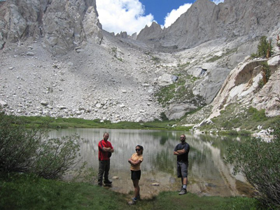
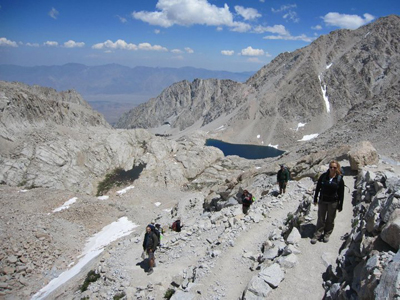
The scenery significantly improves quickly above Outpost Camp. The next named feature along the trail is Mirror Lake, a very pretty and round alpine lake with excellent views of some of the subsidiary peaks of Mt. Whitney situated at about 10,800ft. You have to step about 25 feet down and off the trail to get down to the lake. Most hikers were so focused on the summit that they seemed to skip this—a real shame. I relate this to Mt. Washington and the Tuckerman’s Ravine Trail, where many hikers skip the 20-foot staircase to view the lovely Crystal Cascade only about 0.3 mile past the AMC Pinkham lodge. Here is what you are rewarded with for taking the extra 25 feet down to the lake:
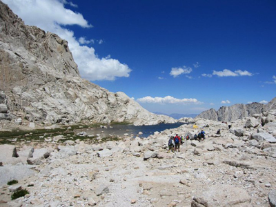
The trees quickly become sparser as you climb above Mirror Lake and shortly thereafter you go above treeline. At this point the views are outstanding all-around and they stay that way for the last 5.5 or so miles to the summit.
Altitude was not really affecting any of us at this point, nor did we meet anyone along the trail that appeared to be suffering here.
After Mirror Lake is Trailside Meadow, a long thin stretch of lush green terrain adjacent to a stream. Above the meadow, you walk a few switchbacks and you soon find yourself at Trail Camp (12,040 feet). A lot of people bash Trail Camp—some will even say that it’s a dreadful place. In our opinion that’s not really fair, because the views from the camp are first-rate. It does get crowded though – expect 30 or 50 people on the average summer night up here. It’s also notoriously windy up here, so you’ll want to bring a good tent and you will need to stake it down very well. Some of the most aggressive marmots on the planet reside here, so make sure all food & toiletries are in your bear canister at all times. We learned from a ranger that bear canisters should NEVER be kept in the tent or in your backpack because the marmots will eat through both of them. Some even recommend leaving your tent open while you hike to the summit so that the marmots can take a peek into your tent and realize there is nothing for them.
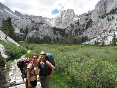
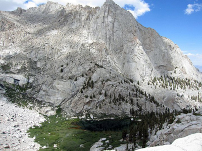
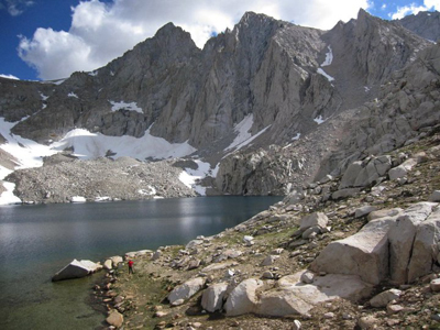
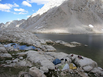
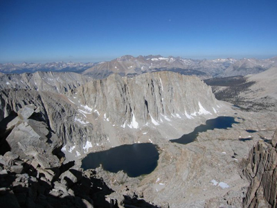
We actually took a bit of a detour and skipped the switchbacks between Trailside Meadow and Trail Camp to visit stunning Consultation Lake. This is the prettiest lake on the eastern side of Mt. Whitney in our opinion, and it is just far enough off the trail that 95% of the hikers either don’t know of its existence, or they do know about it, but skip it anyway to continue climbing upward. The lake is surrounded on three sides by massive mountain walls. Snow lingers in some areas for most of the summer, adding to the wild character of the spot. The fishing here is excellent, and there are usually one or two fishermen here during the middle of the day catching the hundreds of jumping fish that live here. We loved this lake so much that we decided to set up camp here. We had our choice of about a half-dozen or so good and flat pre-established campsites. To our surprise, we had the entire lake to ourselves for the night.
It may be a somewhat selfish thing, but one of my favorite experiences in the outdoors is occasionally having a place completely to ourselves, even if just for a few hours. The beauty of Consultation Lake was captivating, and we couldn’t believe we were the only ones to have chosen to camp along its shores at 11,670ft that night. It was an absolute gift.
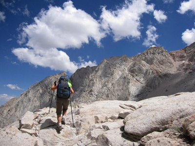
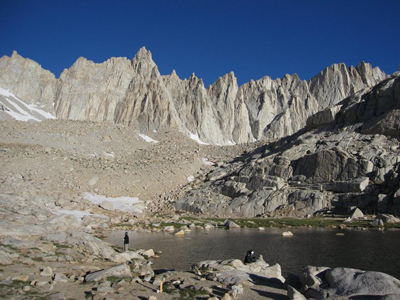
We went to bed early, feeling ready to tackle the summit the next day. We set the alarm for 5:30am so that we could try to summit by 11am. Due to the altitude, one member of our party didn’t have the greatest night sleep. When we all woke up the next morning, it did take a little while to get going. Everything we did at that altitude took a little bit longer. We were all breathing fine, but two or three of the five members of our party had a slight headache when we woke up. We had been camping between 7600ft and 8000ft over the last six days, so we believed that we were relatively acclimated. Despite our efforts to stay hydrate—by forcing water & Gatorade down our throats—it was still tough to drink enough. You had to force yourself to eat and drink more than you naturally wanted to do. After breakfast and a lot of water, everyone eventually felt better. We left camp at about 6:30am and began with an easy scramble above Consultation Lake to rejoin the trail a hundred or two feet below Trail Camp. We arrived at Trail Camp and found that most hikers had already left for their summit bid. We used the small lake that lies beside the camp to top off our water supplies and then we were off to the famous 99 switchbacks (or 97 switchbacks, depending on who you talk to).
The switchbacks weren’t as tedious as we thought they were going to be, mainly because they are all well-graded and extremely varied in length. Some were 20-feet long; others were perhaps 300-feet long. This variety, along with the outstanding views of the Whitney Crest, kept us engaged in the hike.
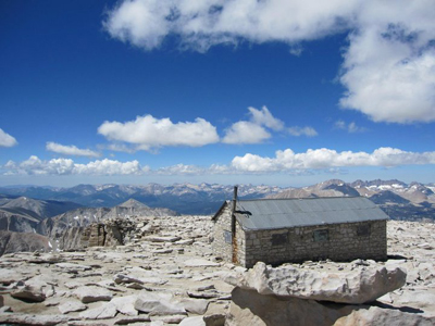
One young hiker we met, maybe 15 years old, appeared to be in a little bit of trouble. He was occasionally stumbling as he walked and was partially incoherent. This was definitely a moderate case of AMS. We stopped to inquire if he was alone, and he informed us that several members of his party were ahead and some were behind him. We left him resting and we continued onward. I assume that he ended up turning around because I never saw him again. Another member of our group may have seen him again, but I’m not sure. This was a classic case where people did not stay together at high-altitude—a selfish and dangerous game in our opinion. There are two or three sections along this section of trail that have precipitous drop offs, so you do have to be coherent and careful. It’s a good idea to have friends around to help determine your current state of mind. You can’t see the summit for the final 10 or 15 minute push of switchbacks to the summit, but before you know it you can see the summit building and you know that you’ve made it! We summited about 11:30am.
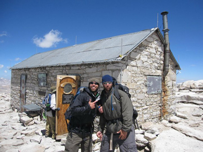
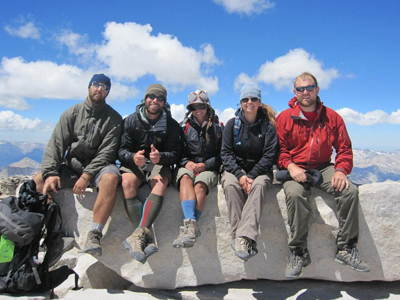
The feeling was awesome, but we were also very nervous about being this high—after all, it was first 14er for each of us. In retrospect, there really wasn’t much for us to worry about because it was a beautiful day and we all felt reasonable well. One member of our party did feel increasingly nauseous as we lingered on the summit, so they descended after only ten minutes with another member of our party.
The hike down back to camp was fast and easy. As expected, we all felt more energized as we lost a few thousand feet of elevation. We returned to Consultation Lake by around 2pm. We decided that we’d head down instead of spending a second night at the lake. We took forever to pack up camp, as we found ourselves in slow-motion due to the altitude and the fact that we had been eating less than normal (due to the slight loss of appetite that most of us experienced).
If you are in reasonable shape and are properly acclimated, Mt. Whitney really isn’t that hard of a mountain to conquer. As long as you have experience backpacking and are hiking with partners that are you comfortable with, you can summit this mountain. It has been said that the toughest part of climbing this mountain is obtaining permits for exactly when you want them, and we’d have to agree with that.
TIPS ON CLIMBING MT. WHITNEY:
|