Top 10 Hikes in the White Mountains
I am proud to present what I believe to be the top ten day hikes in the White Mountains region of New Hampshire! This list is based upon a mix of personal experience of hiking nearly all of the major trails in the White Mountains, plus a thorough review of dozens of websites and just about every hiking guidebook that has been published on this area over the last fifteen years.
Each of these hikes in or near the White Mountain National Forest is outstandingly scenic - you can't go wrong with any of them (except, of course, if you hike them in poor weather). Take note that this list is in alphabetical order - it is not sorted by rank.
Follow New England Waterfalls on Facebook! 
BALDFACE LOOP
| STATE |
TOTAL MILEAGE |
DIFFICULTY |
NOTES & HIGHLIGHTS |
| NH |
9.7 miles |
Difficult |
this is a challenging, classic loop over both South Baldface & North Baldface (tip: most do it clockwise); each of the Baldfaces offers outstanding views; most will agree that this is the best hike in the Evans Notch region of the White Mountains; do not attempt this hike when wet as ledges can be dangerous; plentiful blueberries in season (typically early August); don't miss swimming at the cold but gorgeous Emerald Pool on your way out; can be done as a backpack by staying at Baldface Shelter en route; access via marked trailhead off NH 113 north of Fryeburg, Maine |
MOUNT ADAMS
| STATE |
TOTAL MILEAGE |
DIFFICULTY |
NOTES & HIGHLIGHTS |
| NH |
Varies, but shortest option is 8.6 miles |
Very Difficult |
the favorite NH peak of many hikers, Mt. Adams is ruggedly spectacular; offers alpine views in all directions; there are over a dozen loop options to choose from when climbing this peak; do not attempt in foul weather; don't miss the waterfalls of Appalachia on the way up (or down); can combine with Mt. Madison or Mt. Jefferson, but doing two of three of these in one day is very difficult; you will absolutely want to bring a map for this one; typically snow-free from early June to early October; must trails begin at the 'Appalachia' parking lot on US 2 west of Gorham |
THE BONDS TRAVERSE & ZEACLIFF
| STATE |
TOTAL MILEAGE |
DIFFICULTY |
NOTES & HIGHLIGHTS |
| NH |
19.5 miles |
Very Difficult |
A 'Bonds Traverse' includes the peaks of West Bond, Mount Bond and Bondcliff; these peaks are often hiked together as part of a long and tough one-day traverse from a trailhead on Zealand Road (off US 302) to the Lincoln Woods trailhead (off NH 112), or vice versa; many will hike as part of a 1-2+ night overnight trip (lodging available at Zealand Falls Hut & Galehead Hut; shelter & backcountry tenting available at Guyot Shelter); views from all three summits are wildly spectacular; do not attempt in foul weather; the view from Bondcliff is legendary (see below for picture) |
MOUNT CHOCORUA
| STATE |
TOTAL MILEAGE |
DIFFICULTY |
NOTES & HIGHLIGHTS |
| NH |
Varies, but most popular option is 7.6 miles |
Moderate Side of Difficult |
features a big, open rocky summit with more than enough room to fit the massive crowded that convene here; several route options can be found on each face of the mountain, and all are rewarding; a first big summit for so many young hikers in New England; backcountry lodging available nearby at the Jim Liberty Cabin (see below for picture of summit from the cabin); easiest route to summit is via Champney Falls Trail off the Kancamagus Highway (this is an out-and-back hike); the best loop is probably the Brook Trail + Liberty Trail loop off Paugus Road west of Conway |
MOUNT LINCOLN / MOUNT LAFAYETTE LOOP (THE 'FRANCONIA RIDGE')
| STATE |
TOTAL MILEAGE |
DIFFICULTY |
NOTES & HIGHLIGHTS |
| NH |
8.8 miles |
Very Difficult |
most would agree that this is best loop hike in the western side of the White Mountains; the classic loop is counterclockwise: Falling Waters Trail > Franconia Ridge Trail > Greenleaf Trail > Old Bridal Path, but you can also do this clockwise as well; features several miles of fantastic open ridgeline hiking; don't attempt in foul weather and check the weather before setting out on this hike; backcountry lodging available at AMC Greenleaf Hut (reservations required); trailhead is off I-93 heading north from Lincoln (although you can also park at the parking lots in front of the Lafayette Campground off I-93 heading south) |
MOUNT WASHINGTON
| STATE |
TOTAL MILEAGE |
DIFFICULTY |
NOTES & HIGHLIGHTS |
| NH |
8.4 miles |
Very Difficult |
New England's most alpine and tallest mountain is climbed by thousands each year; the views are absolutely fantastic on all approach trails; the most popular route is as follows: Tuckerman's Ravine > Lion's Head Trail loop; the mountain is actually easier from the west side as follows: Ammonoosuc Ravine Trail > Jewell Trail loop; the Huntington Ravine Trail is the steepest of the approach trails and should NOT be attempted when icy or wet; always be prepared for windy and potentially poor weather on this mountain (it can snow any day of the year); many hikers have died on this mountain, so do your research on this mountain before you try to hike it (and bring a good trail map) |
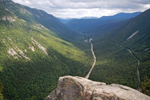
MOUNT WILLARD
| STATE |
TOTAL MILEAGE |
DIFFICULTY |
NOTES & HIGHLIGHTS |
| NH |
3.2 miles |
Easy Side of Moderate |
offers wide, unbeatable scenic views of Crawford Notch; an outstanding adventure for first-time hikers; a favorite (and relatively easy) winter snowshoeing trip; trailhead begins near the AMC Highland Center Lodge on US 302 |
WELCH & DICKEY LOOP
| STATE |
TOTAL MILEAGE |
DIFFICULTY |
NOTES & HIGHLIGHTS |
| NH |
4.5 miles |
Moderate |
only two hours north of Boston, this loop has fantastic views and is one of the top 10 "bang for the buck" hikes in New England; do not hike when wet or icy since the open slabs will be slippery; trailhead access is off Orris Road near Waterville Valley (off NH 49); typically snow and ice-free from early May to mid-October |
WEST RATTLESNAKE
| STATE |
TOTAL MILEAGE |
DIFFICULTY |
NOTES & HIGHLIGHTS |
| NH |
1.8 miles |
Easy Side of Moderate |
one of the best views of lakes to be found anywhere in New England; trailhead is located north of Squam Lake on NH 113; access via the moderately steep Old Bridle Path (out-and-back); photographs never do this place justice, so you'll just have to make a visit yourself; closed for most of April and May each year due to "mud season" |
OTHER LISTS BY NEWENGLANDWATERFALLS.COM
Here are some more lists to help you enjoy the awesome hiking trails of New England:
- Top 25 Hikes in the White Mountains of New Hampshire = link
- Top 25 Hikes in New England = link
- Top 25 Hikes in New Hampshire = link
- Top 25 Easy Day Hikes in New England = link
- Top 25 Loop Hikes in New England = link
- Top 25 Family-Friendly Hikes in New England = link
- Top Rock Scrambles in New England = link
- Hiking New Hampshire's 4000-Footers = link
- Hiking New Hampshire's 52 Peaks With A View List = link
- Hiking the North Shore of Massachusetts / North of Boston = link
|