Top 25 Hikes in the White Mountains
I am proud to present what I believe to be the top 25 hikes in the White Mountains region of New Hampshire! This list is based upon a mix of personal experience of hiking nearly all of the major trails in the White Mountains, plus a thorough review of dozens of websites and just about every hiking guidebook that has been published on this area over the last 15 years.
Each of these hikes in or near the White Mountain National Forest is outstandingly scenic - you can't go wrong with any of them (unless, of course, if you hike them in poor weather). Take note that this list is in alphabetical order - it is not sorted by rank.
Follow New England Waterfalls on Facebook! 
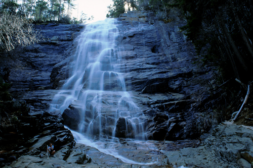
ARETHUSA FALLS
| STATE |
TOTAL MILEAGE |
DIFFICULTY |
NOTES & HIGHLIGHTS |
| NH |
3.2 miles |
Moderate |
arguably the finest waterfall in all of New England; 160-foot tall gorgeous horsetail-style falls; can be combined with a hike to nearby Ripley Falls and a hike up Frankenstein Cliffs; popular with ice climbers in winter; a great (and relatively safe) snowshoeing adventure in winter; trailhead is off US-302 in Crawford Notch State Park (look for road sign); en route to Arethusa Falls, take the spur trail to see Bemis Brook Falls and Coliseum Falls as well |
BALDFACE LOOP
| STATE |
TOTAL MILEAGE |
DIFFICULTY |
NOTES & HIGHLIGHTS |
| NH |
9.7 miles |
Difficult |
this is a challenging, classic loop over both South Baldface & North Baldface (tip: most do it clockwise to go up the steepest section instead of down it); each of the Baldfaces offers outstanding views; most will agree that this is the best hike in the Evans Notch region of the White Mountains; do not attempt this hike when wet or icy as the ledges on South Baldface can be dangerous; plentiful blueberries in season (typically early August); don't miss swimming at the cold but gorgeous Emerald Pool on your way out; can be done as a backpack by staying at Baldface Shelter en route; access via a well-marked trailhead on NH 113 in Evans Notch |
BONDS TRAVERSE
| STATE |
TOTAL MILEAGE |
DIFFICULTY |
NOTES & HIGHLIGHTS |
| NH |
19.5 miles
(add 3.7 miles when Zealand Road is closed for winter) |
Very Difficult |
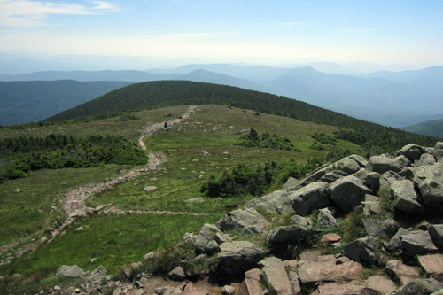
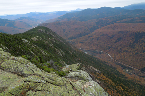
A 'Bonds Traverse' includes the peaks of West Bond, Mount Bond and Bondcliff; these peaks are often hiked together as part of a long and tough one-day traverse from a trailhead on Zealand Road (off US 302) to the Lincoln Woods trailhead (off NH 112), or vice versa; many will hike as part of a 1-2+ night overnight trip (lodging available at Zealand Falls Hut & Galehead Hut; shelter & backcountry tenting available at Guyot Shelter); views from all three summits are wildly spectacular; do not attempt in foul weather; the view from Bondcliff is legendary (see below for picture) |
KEARSARGE NORTH
| STATE |
TOTAL MILEAGE |
DIFFICULTY |
NOTES & HIGHLIGHTS |
| NH |
6.2 miles |
Moderate Side of Difficult |
gorgeous views of the eastern White Mountains from the empty but enclosed fire-tower on the top; access via Hurricane Road just north of North Conway; ledges can be difficult when icy or wet; one of the finest 1/2 to full day hikes in the White Mountains; the trailhead is plowed in winter, so this is a great 4-season hike (once the snow base is deep enough, it is an awesome snowshoe trip) |
MIDDLE & NORTH SUGARLOAF
| STATE |
TOTAL MILEAGE |
DIFFICULTY |
NOTES & HIGHLIGHTS |
| NH |
2.6 miles to Middle Sugarloaf only;
3.2 miles to both Middle & North Sugarloaf |
Moderate |
one of the great "bang for the buck" hikes in the White Mountains; a hike of only 2.6 miles brings you to the summit of Middle Sugarloaf, which offers some of the finest views in the White Mountains from huge open ledges; extend your hike to 3.2 miles in total and you can also visit North Sugarloaf, which offers excellent views from two different viewpoints; access via well-marked trailhead off Zealand Road (open seasonally; located off US 302); the trail to both summits is a moderate climb with a fair amount of elevation gain, and there is also a tall but secure ladder in place on the way to Middle Sugarloaf that those with a strong fear of heights may not appreciate; if you finish this hike and want more, combine with nearby Mt. Willard, which is another classic 'bang for the buck' hike. |
MOUNT ADAMS
| STATE |
TOTAL MILEAGE |
DIFFICULTY |
NOTES & HIGHLIGHTS |
| NH |
Varies, but shortest option is 8.6 miles |
Very Difficult |
the favorite NH peak of many hikers, Mt. Adams is ruggedly spectacular; offers alpine views in all directions; there are over a dozen loop options to choose from when climbing this peak; do not attempt in foul weather; don't miss the waterfalls of Appalachia on the way up (or down); can combine with Mt. Madison or Mt. Jefferson, but doing two of three of these in one day is very difficult; you will absolutely want to bring a map for this one; typically snow-free from early June to early October; must trails begin at the 'Appalachia' parking lot on US 2 |
MOUNT CARRIGAIN
| STATE |
TOTAL MILEAGE |
DIFFICULTY |
NOTES & HIGHLIGHTS |
| NH |
10.0 miles
(add 4.0 miles when Sawyer River Road is closed in winter) |
Moderate Side of Difficult |
many consider the view from the open fire-tower platform on Mt. Carrigain to be the finest view of all peaks in all of the White Mountain National Forest; the open views on Signal Ridge are equally fantastic; in winter, the hike is 14.0 miles round trip as the Sawyer River Road is gated (adds 2-mile relatively easy miles each way; you can cross-country ski the road); views of Mt. Washington on a clear day from both Signal Ridge and the summit are outstanding |
MOUNT CHOCORUA
| STATE |
TOTAL MILEAGE |
DIFFICULTY |
NOTES & HIGHLIGHTS |
| NH |
Varies, but most popular option is 7.6 miles |
Moderate Side of Difficult |
features a big, open rocky summit with more than enough room to fit the massive crowded that convene here; several route options can be found on each face of the mountain, and all are rewarding; a first big summit for so many young hikers in New England; backcountry lodging available nearby at the Jim Liberty Cabin (see below for picture of summit from the cabin); easiest route to summit is via Champney Falls Trail off the Kancamagus Highway (this is an out-and-back hike); the best loop is probably Brook Trail + Liberty Trail loop |
MOUNT CRAWFORD
| STATE |
TOTAL MILEAGE |
DIFFICULTY |
NOTES & HIGHLIGHTS |
| NH |
5.0 miles |
Moderate Side of Difficult |
360-degree views from open summit; trailhead is found off US 302 |
MOUNT EISENHOWER
| STATE |
TOTAL MILEAGE |
DIFFICULTY |
NOTES & HIGHLIGHTS |
| NH |
6.6 miles |
Moderate Side of Difficult |
excellent 360-degree views from bald summit, including some of Presidential Range peaks; a huge cairn marks the summit; an excellent "above treeline" hike/mountain for first-time hikers; most take the Edmunds Path from the paved Mt. Clinton Road (open seasonally); in winter, this is typically hiked by hiking north from Mt. Pierce |
MOUNT GARFIELD
| STATE |
TOTAL MILEAGE |
DIFFICULTY |
NOTES & HIGHLIGHTS |
| NH |
10.0 miles |
Moderate |
hike the Garfield Trail to see the beautiful panoramic view of the Pemigewasset Wilderness from the summit; approach is generally easy with one short but semi-rough section just before the top; can be combined with Mt. Galehead for a long but tough loop (short road walk required); backcountry lodging available at the nearby Garfield Ridge Shelter (looks more like a cabin than a shelter) or the AMC Galehead Hut (reservations required); this is a fantastic snowshoeing trip in the winter, but the access road will be closed and this adds more miles to your hike |
MOUNT JEFFERSON
| STATE |
TOTAL MILEAGE |
DIFFICULTY |
NOTES & HIGHLIGHTS |
| NH |
5.0 miles |
Difficult |
one of the northern Presidential-range peaks; the most common route is via the scrambly Caps Ridge Trail (5.0 miles round-trip) off Jefferson Notch Road (open seasonally), but there are other alternative routes (Jewell Trail, for example); 360-degree alpine views; in winter, you must take a different and longer approach to climb Jefferson |
MOUNT LIBERTY & MOUNT FLUME LOOP
| STATE |
TOTAL MILEAGE |
DIFFICULTY |
NOTES & HIGHLIGHTS |
| NH |
9.8 miles |
Difficult |
open views are obtained from both of these summits; you can either do a 9.8 mile loop over both summits (but you'll have to scramble up the very steep and dangerous-when-wet Flume Slide Trail) or you can do a 10.2 mile out-and-back hike up Mt. Liberty and scoot over to Mt. Flume (return the way you came); trailhead is off US 3 near The Flume |
MOUNT LINCOLN / MOUNT LAFAYETTE LOOP (the 'FRANCONIA RIDGE')
| STATE |
TOTAL MILEAGE |
DIFFICULTY |
NOTES & HIGHLIGHTS |
| NH |
8.8 mile counterclockwise loop |
Very Difficult |
most would agree that this is best loop hike in the western side of the White Mountains; the classic loop is counterclockwise: Falling Waters Trail > Franconia Ridge Trail > Greenleaf Trail > Old Bridal Path, but you can also do this clockwise as well; features several miles of fantastic open ridgeline hiking; don't attempt in foul weather; backcountry lodging available at AMC Greenleaf Hut (reservations required); trailhead is off I-93 heading north from Lincoln (although you can also park at the parking lots in front of the Lafayette Campground off I-93 heading south) |
MOUNT MADISON
| STATE |
TOTAL MILEAGE |
DIFFICULTY |
NOTES & HIGHLIGHTS |
| NH |
Varies, but most common route is 8.4 miles |
Difficult |
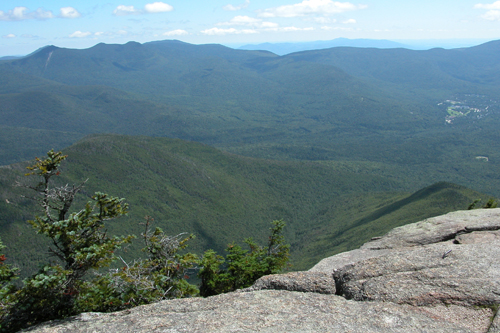
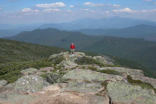
one of the famed peaks of the Northern Presidentials, Mt. Madison has an alpine summit with 360-degree views; lodging available at Madison Hut (reservations required); don't miss the view of Mt. Madison from Star Lake, which is a short detour from the Madison Hut (see below for picture); most common route is up and down Valley Way, but there are more attractive approach trails you can take to bring you up to Madison Hut, which sits just 0.5 mile below the summit |
MOUNT MOOSILAUKE
| STATE |
TOTAL MILEAGE |
DIFFICULTY |
NOTES & HIGHLIGHTS |
| NH |
7.5 miles at a minimum |
Difficult |
one of the most famous of NH's 4000-footers; wide open alpine views; several different route options available; the easiest is the 7.5 mile loop up Gorge Brook and returning via Carriage Road and Snapper Trail; do not attempt in poor weather |
MOUNT OSCEOLA
| STATE |
TOTAL MILEAGE |
DIFFICULTY |
NOTES & HIGHLIGHTS |
| NH |
6.4 miles |
Moderate Side of Difficult |
spacious, flat summit with outstanding 180-degree views; easiest access to this "4000-er" is via Mt. Osceola Trail from Tripoli Road (open seasonally); often combined with viewless East Osceola Peak (another 4000-footer); can also be reached from the Kancamagus Highway but this route is much steeper and more difficult |
MOUNT WASHINGTON
| STATE |
TOTAL MILEAGE |
DIFFICULTY |
NOTES & HIGHLIGHTS |
| NH |
8.4 miles at a minimum |
Very Difficult |
New England's most alpine and tallest mountain is climbed by thousands each year; views are absolutely fantastic on all approach trails; the most popular route is as follows: Tuckerman's Ravine > Lion's Head Trail loop; the mountain is actually easier from the west side as follows: Ammonoosuc Ravine Trail > Jewell Trail loop; the Huntington Ravine Trail is the steepest of the approach trails and should not be attempted when icy or wet; always be prepared for windy and potentially poor weather on this mountain; many hikers have died on this mountain, so do your research on this mountain before you try to hike it |
MOUNT WILLARD
| STATE |
TOTAL MILEAGE |
DIFFICULTY |
NOTES & HIGHLIGHTS |
| NH |
3.2 miles |
Easy Side of Moderate |
offers wide, scenic views of Crawford Notch; an outstanding adventure for first-time hikers; a favorite (and relatively easy) winter snowshoeing trip; trailhead begins near AMC Crawford Notch Depot on US 302; while you are parked at the trailhead, also consider exploring other nearby attractions, including: Ammonoosuc Lake, Beecher & Pearl Cascades, Gibbs Falls, and Crawford Cliff |
PINE MOUNTAIN
| STATE |
TOTAL MILEAGE |
DIFFICULTY |
NOTES & HIGHLIGHTS |
| NH |
3.5 mile loop |
Moderate |
awesome views for the effort involved (a very high 'bang for the buck' hike); popular with campers staying at the extremely large and nearby Dolly Copp Campground; park at the trailhead for the Pink Link trail off Pinkham B Road (a dirt road that is usually open and passage by all vehicles from May to October); 2.5 miles of the 3.5 mile total distance is done by walking along a dirt road; some minor hand-scrambling is involved on the 0.6 mile southern portion of the Ledge Trail, but most hikers will not find it particular difficult; several excellent outlooks, especially at the top; look for the specially-carved granite seat for two at the top |
SOUTH TWIN
| STATE |
TOTAL MILEAGE |
DIFFICULTY |
NOTES & HIGHLIGHTS |
| NH |
11.2 miles |
Moderate Side Of Difficult |
good views en route (on North Twin, another 4000-footer) and awesome 360-degree views from the open summit of South Twin; difficult river crossings when water is running high; backcountry lodging available at AMC Galehead Hut (make reservations months in advance) |
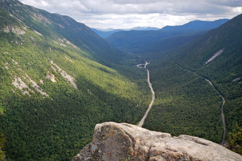
WEBSTER CLIFF TRAIL / MT. WEBSTER
| STATE |
TOTAL MILEAGE |
DIFFICULTY |
NOTES & HIGHLIGHTS |
| NH |
6.6 miles |
Moderate Side Of Difficult |
several open views from the ledges on the side of Mt. Webster provide probably the finest views of Crawford Notch; with a carspot, you can easily extend this hike add Mt. Jackson (scenic views), AMC Mizpah Spring Hut (offers overnight lodging) and even Mt. Pierce (scenic views) to the hike; trailhead off US 302 just south/east of the AMC Crawford Notch Depot |
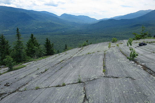
WELCH & DICKEY LOOP
| STATE |
TOTAL MILEAGE |
DIFFICULTY |
NOTES & HIGHLIGHTS |
| NH |
4.5 miles |
Moderate |
only two hours north of Boston, this loop has fantastic views and is one of the top 10 "bang for the buck" hikes in New England; do not hike when wet or icy since the open slabs will be slippery; trailhead access is near Waterville Valley; typically snow-free from early May to mid-October; do not park in areas marked "no parking" as this is strictly enforced by the town |
WEST RATTLESNAKE
| STATE |
TOTAL MILEAGE |
DIFFICULTY |
NOTES & HIGHLIGHTS |
| NH |
1.8 miles |
Easy Side of Moderate |
one of the best views of lakes to be found anywhere in New England; located north of Squam Lake; access via the moderately steep Old Bridle Path (out-and-back); photographs never do this place justice, so you'll just have to make a visit yourself; closed for most of April and May each year due to the "mud season" |
ZEACLIFF
| STATE |
TOTAL MILEAGE |
DIFFICULTY |
NOTES & HIGHLIGHTS |
| NH |
7.8 miles |
Moderate Side of Difficult |
one of the top viewpoints in all of New Hampshire; often combined with a hike to viewless Zealand Mountain (one of the 48 4000-footers); lodging available at nearby AMC Zealand Falls Hut (reservations required); Zeacliff is also a common stop on a tough "Bonds Traverse" day or overnight hike |
RUNNER-UPS
Each of the following hikes was a close contender for the Top 25 hikes list above. I highly recommend each of these hikes as well. In fact, I would rate each of them a '9.5' or '10.0' for scenic beauty:
| THE HIKE |
STATE |
TOTAL MILEAGE |
DIFFICULTY |
NOTES & HIGHLIGHTS |
| Bridal Veil Falls |
NH |
5.0 miles |
Moderate |
one of the loveliest (and easiest) half-day hikes in New Hampshire; beautiful waterfall is found at the end of the Coppermine Trail; don't miss the Bette Davis plaque (if you can find it - it is about 50 feet off of the trail); trailhead is on Coppermind Road, which is off NH 116 near the Franconia Inn |
| Boulder Loop Trail |
NH |
3.1 miles |
Moderate |
one of the nicest half-day loops in the White Mountains; several views from open ledges; trailhead is found near the eastern end of the Kancamagus Highway (NH 112) |
| Glen Ellis Falls |
NH |
0.6 miles |
Easy |
beautiful 64-foot plunge waterfall in Pinkham Notch off NH 16; there are stairs that bring you down to the base of the falls that can be very slippery when wet or icy, so be careful |
| Mount Hight / Carter Dome |
NH |
10.0 miles |
Moderate Side of Difficult |
bag a 4000-footer (Carter Dome) and one of the best views in the White Mountain (Mt. Hight) on a "lollipop loop" hike; trailhead off US 16 north of Jackson |
| Mount Morgan / Mount Percival |
NH |
5.4 miles |
Moderate |
features excellent views and also several fun trail ladders & boulder caves; one of the finest half-day hikes in the southern White Mountains; boulder caves not recommended in wet or icy conditions |
| Mount Pemigewasset |
NH |
3.8 miles |
Moderate |
great views from open ledge at summit; trailhead is off US 3, just north of the town of Lincoln and the Kancamagus Highway; one trailhead is located with the parking lot of The Flume |
| Mount Roberts |
NH |
5.0 miles |
Moderate |
great family-friendly day hike near the Castle in the Clouds; there are views en route from several ledges and there is also a fine view of Mt. Washington from the summit itself; free access and parking if you avoid taking the scenic drive up to the castle |
| North Moat Mountain & Red Ridge Loop |
NH |
10.2 miles |
Difficult |
the 360-degree views on this magnificent summit are some of the best in the White Mountains region; don't miss splashing in fun Diana's Baths on the way out; you can also hike the Moats (North, Middle and South peaks) as a 9.7 mile traverse from West Side Road in North Conway to Dugway Road in Conway if you have two vehicles; the regular trailhead for the loop is the Diana's Baths trailhead off West Side Road in North Conway |
| North Percy Peak |
NH |
4.4 miles |
Difficult |
an off-the-beaten-path "North Woods" area hike; involves scrambling on ledges, which are dangerous when wet; you can also take a rough path to South Percy, although North Percy is a finer peak; access via Nash Stream Rd |
| Sandwich Dome |
NH |
8.3 miles
(not including spur trail to Jennings Peak) |
Difficult |
fantastic views from Jennings Peak (make sure to hike this additional spur trail) and Sandwich Dome; loop using Sandwich Mountain Trail and Drake's Brook Trail off NH 49; some steep sections; Sandwich Dome can also be climbed via the Algonquin Trail off Sandwich Notch Road (which is seasonal and can be in poor shape any time of the year) |
| Shelburne Moriah Mountain |
NH |
11.0 miles |
Difficult |
beautiful views from ledges on a relatively uncrowded mountain; most commonly climbed via (a) Rattle River Trail > Kenduskeag Trail or (b) Shelburne Trail > Kenduskeag Trail (both are 11.0 miles round-trip) |
| Table Rock |
NH |
estimated at 2.2 miles |
Difficult |
there are three trails to this ledgy view in Dixville Notch (one is very steep and the others are much less so); this hike is quite a far distance north from most attractions of the White Mountains, so you might as well also visit Huntington Cascades and Dixville Flume while in the area |
OTHER LISTS BY NEWENGLANDWATERFALLS.COM
Here are some more lists to help you enjoy the awesome hiking trails of New England:
- Top 10 Hikes in the White Mountains of NH = link
- Top 25 Hikes in New Hampshire = link
- Top 25 Hikes in New England = link
- Top 25 Easy Day Hikes in New England = link
- Top 25 Loop Hikes in New England = link
- Top 25 Family-Friendly Hikes in New England = link
- Top Rock Scrambles in New England = link
- Hiking New Hampshire's 4000-Footers = link
- Hiking New Hampshire's 52 Peaks With A View List = link
- Hiking the North Shore of Massachusetts / North of Boston = link
|