New England Waterfalls hompeage Connecticut Waterfalls Maine Waterfalls Massachusetts Waterfalls New Hampshire Waterfalls Rhode Island Waterfalls Vermont Waterfalls Top 100 US Waterfalls New England Waterfalls guidebook on Amazon New England Waterfalls guidebook on Amazon New England Waterfalls header bar

BACKPACKING IN MASSACHUSETTS
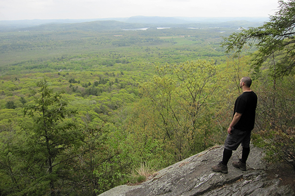
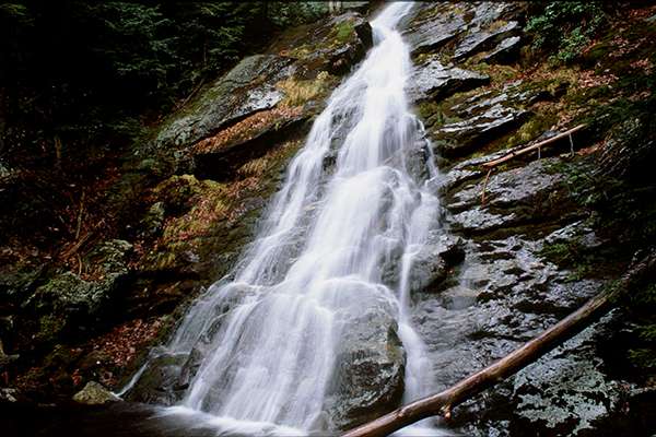
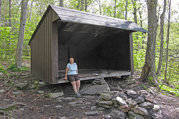
views from Mt. Race Race Brook Falls Pecks Brook Falls, Mount Greylock

Welcome to the Newenglandwaterfalls.com guide to backpacking in Massachusetts!

You'll find a lot of opportunities for backpacking in Massachusetts, especially in the Berkshires region. The Appalachian Trail passes through a good chunk of western Massachusetts, but that's hardly the only trail worth backpacking in the state.

The premier backpacking destinations of Massachusetts include:
  • Appalachian Trail - 91 miles from the Connecticut border to the Vermont border
  • Midstate Trail
  • Mount Greylock State Reservation
  • Mount Washington State Forest
If you are going to go backpacking in Massachusetts, pick up a copy of the latest edition of these long-trusted and excellent guidebooks: AMC's Best Backpacking in New England (2nd edition) , and AMC's Massachusetts Trail Guide (11th edition; 2021).

Here is a list of all of the fantastic backpacking opportunities in Massachusetts. If you think I've missed any backpacking trips in Massachusetts, please email me @ gparsons66@hotmail.com.

Follow New England Waterfalls on Facebook! facebook icon


MOUNTAIN / DESTINATION AREA / REGION SCENIC / VIEW RATING # OF NIGHTS LODGING TYPE CROWD LEVEL NOTES & DESCRIPTION (is there a fee charged?)
Alander Mountain Cabin  Southern Berkshires 7 / 10 1 cabin, tent sites moderate there is one cabin near the summit of Alander Mountain and two tent sites less than a mile away on its eastern slope; the cabin is functional but it is definitely not visually appealing in any way; the cabin and summit can be reached from several directions, including from Bash Bish Falls State Park from the north and a trailhead on Under Mountain Road from the south; there are a lot of trails in this area so you can design a larger loop or lollipop loop if you want (consult a trail map)
Appalachian Trail Berkshires 9 / 10 7-10 shelters, tent sites moderate to very high 90.2 miles of the Appalachian Trail reside in Massachusetts; the elevation range of this section of the trail ranges from 650ft to 3,491ft; there are many shelters and tent sites along the way; the best sections are in the southern and northern portions of the state (the central section is quieter but also less interesting)
Buck Hill Shelter Spencer unknown 1 shelter low to moderate one of several lightly-used shelters on the Midstate Trail
Douglas State Forest Shelter Douglas unknown 1 shelter low to moderate one of several lightly-used shelters on the Midstate Trail; this is the southernmost shelter along the Midstate Trail
Glen Brook Shelter Southern Berkshires 8 / 10 1 shelter moderate this shelter is along the Appalachian Trail just north of Mt. Everett; typical access is by hiking north along the Appalachian Trail from the parking lot at the end of the road that ends a short distance below the summit of Mt. Everett; you can also reach this shelter from the Berkshire School off MA 41; if this shelter is full, nearby Hemlocks Shelter may have additional space; see map here: https://www.mass.gov/eea/docs/dcr/parks/trails/mwashington.pdf
Hemlocks Shelter Southern Berkshires 8 / 10 1 shelter moderate this shelter is along the Appalachian Trail just north of Mt. Everett; typical access is by hiking north along the Appalachian Trail from the parking lot at the end of the road that ends a short distance below the summit of Mt. Everett; you can also reach this shelter from the Berkshire School off MA 41; if this shelter is full, nearby Glen Brook Shelter may have additional space; see map here: https://www.mass.gov/eea/docs/dcr/parks/trails/mwashington.pdf
Long Pond Shelter Rutland unknown 1 shelter low to moderate one of several lightly-used shelters on the Midstate Trail; the Midstate Trail runs 95-miles through the center of Massachusetts from the border of Rhode Island to the border of New Hampshire
Monroe State Forest Northwestern Corner 5 / 10 1 shelters low to moderate this state forest currently has three shelters available for use (Dunbar Brook Shelter, Ridge Shelter, and Smith Hollow Shelter); a nice loop (estimated at 9-miles in total) can be completed by connecting the Spruce Hill Trail, Smith Hollow Trail and Dunbar Brook Trail (although views are very limited)
Moose Hill Shelter Spencer unknown 1 shelter low to moderate one of several lightly-used shelters on the Midstate Trail; the Midstate Trail runs 95-miles through the center of Massachusetts from the border of Rhode Island to the border of New Hampshire
Mt. Greylock / Bellow's Pipe Shelter Northern Berkshires 7 / 10 1 shelter, tent sites moderate to high first come-first served; limit is 12 people; tenting is permitted in general vicinity of shelter; there are several approach trails, including from the Bellows Pipe Trail from Notch Road, Bellows Pipe Trail from Thiel Road, and by coming directly down from the summit of Mount Greylock (great views); day trip to the summit of Mt. Greylock possible from this shelter
Mt. Greylock / Deer Hill Shelter Northern Berkshires 5 / 10 1 shelter, tent sites moderate first come-first served; limit is 12 people; tenting is permitted in general vicinity of shelter; this shelter is tucked away on the western slope of Mount Greylock and is in a location that  does NOT serve well as a basecamp for hiking to the summit (other shelters are closer to the summit or have trails that lead to the summit); Deer Hill Falls is nearby and is fairly impressive in high water (but can be less than thrilling in low water)
Mt. Greylock / Mark Noepel Shelter Northern Berkshires 7 / 10 1 shelter, tent sites moderate to high first come-first served; limit is 12 people; tenting is permitted in general vicinity of shelter; this is a good place to stay if you want to hike to the summit of Mt. Greylock as part of your adventure; this shelter is located along the Appalachian Trail
Mt. Greylock / Peck's Brook Shelter Northern Berkshires 7 / 10 1 shelter, tent sites moderate to high first come-first served; limit is 12 people; tenting is permitted in general vicinity of shelter; this is a good place to stay if you want to hike to the summit of Mt. Greylock as part of your adventure; shelter is located on a spur trail off the Gould Trail; if hiking to the summit is your primary goal while backpacking in this area, then this would be my pick of all the shelters in the area
Mt. Greylock / Mt. Greylock Campground (Sperry Rd.) Northern Berkshires 5 / 10 1 tent sites moderate to high this family-friendly campground used to be for car-campers, but now you have to backpack in to it; reservations are required for the spring-fall season (www.reserveamerica.com) ($ fee is charged)
Mt. Greylock / Wilbur's Clearing Shelter Northern Berkshires 7 / 10 1 shelter, tent sites moderate to high first come-first served shelter; limit is 12 people; tenting is permitted in general vicinity of shelter; this shelter is tucked away on the northern slope of Mount Greylock and is in a location that  does NOT serve well as a basecamp for hiking to the summit (other shelters are closer to the summit or have trails that lead to the summit);
Mt. Race / Laurel Ridge Southern Berkshires 8 / 10 1 tent sites moderate to high the Laurel Ridge tent site is located along the Appalachian Trail on the southern approach to Mt. Race; is is one of two tent sites in the area (the other is Sages Ravine); Mt. Race has fantastic views and offers fine ridgeline walking
Mt. Race / Race Brook Falls Southern Berkshires 9 / 10 1 tent sites moderate to high don't miss the five distinct set of impressive falls along the Race Brook Trail on the way up to or back from the shelter; nearby Mt. Everett is also worthy of a side trip, especially since cars are no longer allowed to drive to the summit
Mt. Race / Sages Ravine Southern Berkshires 8 / 10 1-2 tent sites moderate to high Sages Ravine with its attractive gorge is an extremely pretty section of the Appalachian Trail; you can use this tent site as a base to climb both Mt. Race (MA) and Bear Mountain (CT), both of which are highly recommended
New England Trail / Richardson-Zlogar Cabin Northfield / Greenfield unknown 1 cabin moderate to high stay at a cabin built in 2012 on the New England Trail; views of Vermont, New Hampshire and Massachusetts; reservations are required at least 1 week in advance; as of Jan 2022, the cabin is unavailable due to COVID-19; https://www.newenglandtrail.org/facilities/richardson-zlogar-cabin
Muddy Pond Shelter Westminster unknown 1 shelter low to moderate 4-6 person lean-to located in the town of Westminster along the Midstate Trail; views of the pond are good right from the lean-to; several internet sites claim this is the best of the shelters on the Midstate Trail; this is the northernmost shelter along the Midstate Trail
October Mountain Shelter Berkshires 6 / 10 1 shelter low to moderate shelter along the Appalachian Trail between West Branch Rd and Lenox-Whitney Place Road
Royalston Falls / Tully Trail / Royalston Falls Shelter North-Central Massachusetts 8 / 10 1 shelter moderate to high this shelter is located a few tenths of a mile above the attractive and 45-foot tall Royalston Falls; shelter is managed by the Trustees of Reservation (a wonderful conservation organization with over 100 properties in Massachusetts); shelter is located on the Tully Trail and would serve as a good 1/2 way point if you wanted to hike the entire Tully Trail loop over a two day period (approximately 21-22 miles with 3200-3300 feet of elevation gain); shelter is first-come, first-served, and is most easily accessed via the Tully Trail trailhead next to a cemetery on MA 68 (Athol-Richmond Road)
Sandy Neck Beach Park Barnstable / Cape Cod 9 / 10 1 tent sites moderate to high currently offers five first-come, first-served campsites; the hike to the campsites is 3.3 miles one-way; purchase your camping permit at the Gatehouse of the park; campsites can be closed seasonally due to nesting shorebirds (such as the piping plover); campsites are a short distance from Cape Cod Bay and are accessible from the beach (nearly 100% walking on sand with no shade) or by combining the Marsh Trail with Trail #4; be aware of mosquitoes and greenhead season when planning your trip; be aware that cars and other vehicles are allowed along the beach (but not at or near the campsites) ($ fee is charged)

views from Mt. Race
views from Mt. Race

Race Brook Falls
Race Brook Falls

Peck's Brook Shelter, Mount Greylock
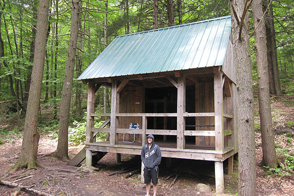

Royalston Falls Shelter
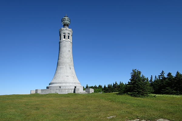

monument at the top of Mount Greylock

TIPS FOR BACKPACKING IN MASSACHUSETTS


1. Get and use the excellent AMC Massachusetts Trail Guide (2016 edition).
2. Use Trailsnh.com, Newenglandtrailconditions.com, Vftt.org or other internet sites to obtain the latest in trail conditions (especially in winter, when conditions can be highly variable).
3. Buy the a guidebooks and actually read each relevant chapter before you take a backpacking trip.
4. Bring friends with you on your backpacking adventures (so long as you sincerely believe they will be capable of hiking these mountains and will actually enjoy the terrain and trails that you are selecting for them).
5. Invest in high-quality hiking shoes or boots.
6. Save your knees so that you can still hike when you are in your 70's (use trekking poles!).
7. Always leave a note or tell someone which mountain and trails you will be hiking (too many people get lost and/or injured in these mountains).
8. Don't leave anything valuable in your car (too many break-ins have been occurring, unfortunately).
9. Learn the value of hitch-hiking, using a car-spot, and/or mountain biking between trailheads (a traverse is always more interesting than an out-and-back hike!).
10. Most people avoid backpacking in Massachusetts from November through April (the conditions are usually not favorable).
11. Start your hikes early (i.e. before 6:30-7:00am) to beat most of the crowds and have a better shot of grabbing a space within a shelter or at an established tent site.
12. Study hiking maps and be creative in the routes you take (you don't always have to take the easiest or most-straightforward trails).
13. Mid-week September hiking is amazing. Hike at least once during this time-frame (call out sick from work if you have to).
14. Carry the appropriate food based on the season you are hiking in (some foods will melt in summer, and some foods become rock-solid in winter).
15. Attack some burgers and beers after at least some of the hikes (or all of them). You've earned it.
16. Get that $20 REI membership to save 8-10% on all full-price REI purchases for the rest of your life (you have no idea how much time you'll probably spend at their stores and on rei.com). Also, strongly consider getting the REI credit card (you can earn hundreds of dollars in dividends each year if you use this credit card as your primary card for your non-REI purchases!).
17. Do the great mountains on the bluebird days, and the less interesting mountains on the overcast or lousy-weather days.
18. Don't miss backpacking in the Berkshires during peak fall foliage.
19. Enjoy that Gatorade (or some other drink that has electrolytes).
20. Ibuprofen can be extremely helpful in controlling pain and/or reducing swelling.
21. Be safe out there - these mountains can be nasty (even deadly) in adverse weather conditions. Snow and ice can also be very problematic.
22. If you are short on hiking friends, consider joining a Meetup hiking group (there are several groups and they always have good hikes planned).
23. Spend time perusing at least a few gear stores that focus on hiking & backpacking equipment.
24. Take a wilderness first aid course.
25. Try to read the weather frequently while hiking, and react quickly to changes in clouds.
26. Don't be afraid to turn back if your energy levels are low or the weather is deteriorating (most hikers will be turned back at some point).
27. Catch a sunset or sunrise from a mountain top (bring at least one headlamp).
28. Always treat water before drinking it (use iodine, boil, or use a filter)
29. Try to limit your first backpacking trip to no more than 6-8 miles a day (some will want to do even less miles than this)
30. Don't forget your camera, and remember to label the pictures after you are done with each hike (you'll want to capture these moments).

BACKPACKING IN THE OTHER NEW ENGLAND STATES


Newenglandwaterfalls.com has also created backpacking guides to some of the other New England states. Those pages can be found here:

BACKPACKING CHECKLIST


Here is a quick packing list for your next backpacking trip. You probably won't want or need to bring all these items, but I have listed them here anyway for your consideration.
  • FOOD & WATER
    • Food and snacks
    • Water
    • Electrolytes drink (i.e. Gatorade, Powerade, etc.)
    • Coffee
  • BACKPACKING GEAR
    • Hiking shoes or hiking boots
    • Backpack
    • Backpack cover or bag liner
    • Tent, tarp-tent, bivy, or hammock
    • Sleeping bag or quilt
    • Sleeping pad
    • Headlamp and batteries
    • Guidebook or route description
    • Permits (if applicable)
    • Trail Map
    • Water bottles and/or water bladder/hydration reservoir
    • Water filter
    • Trash bag
    • Stuff sack
    • Pillow
    • Trekking poles
    • Sunglasses / contacts
    • Camp shoes, down booties, sandals or crocs
    • Gaiters
    • Tent footprint, tarp or ground cloth
    • Fishing gear
    • Sanitation shovel
    • Camp chair
  • CLOTHING
    • Shirts-quick drying
    • Socks
    • Hiking pants, hiking shorts or kilts
    • Waterproof jacket
    • Camp clothing
    • Underwear-quick drying
    • Waterproof hiking pants
    • Fleece jacket, softshell jacket and/or down jacket
    • Bandana and/or face towel
    • Towel
    • Hat
    • Winter hat
    • Winter gloves or mittens
    • Winter facemask or balaclava
  • COOKING & EATING
    • Stove and fuel
    • Cooking utensils
    • Cooking pot and/or cooking bowl
    • Bowls and/or plates
    • Cups
  • COMFORT & TIOLETRIES
    • Tiolet paper
    • Hand sanitizer
    • Baby wipes
    • Toothbrush/toothpaste
    • Earplugs
    • Bug spray
    • Bug net
    • Deodorant
    • Sun-screen lotion
    • Lip balm
    • Aloe Vera
    • Bio-degradeable soap
  • SAFETY & SECURITY
    • Matches or lighter
    • Safety whistle
    • Medical kit
    • Knife, Razor-blade or multi-tool
    • Identification
    • Money/Cash
    • Compass
    • Duct tape or superglue
    • Rope or nylon cord
    • First-aid Handbook
    • GPS
    • Altimeter
    • Signaling mirror
    • Phone
    • Bear bag or canister
    • Watch
    • Personal location beacon ('PLB')
    • Foot traction
    • Ice axe
    • Bear spray
  • FUN STUFF
    • Camera
    • Alcohol/booze
    • Plastic wine glasses
    • Tripod or mini-tripod
    • Playing cards
    • Book/magazine/e-reader
    • Pet supplies
    • Pencil/pen/paper
    • Mini-speakers
    • Miniature lantern
    • Binoculars / monoculars
Click here for a more comprehensive backpacking checklist, including some recommended brands for gear.

HIKING COMMUNITIES ON FACEBOOK


If you enjoy hiking or backpacking in Massachusetts, I recommend that you strongly consider joining some or all of these groups on Facebook. Once accepted into the groups, please share your photos and adventures of hiking and backpacking throughout Massachusetts:
EXPLORE MORE OF NEW ENGLAND!
Connecticut /  Maine /  Massachusetts /  New Hampshire  /  Rhode Island  /  Vermont
Home Page /  About the Book /  Book Updates /  Top 40 Waterfalls /  Swimming Holes /  How To Use This Guide /  Contact Us
Waterfall Photography /  Top 25 New England Hikes /  4000 Footers of NH /  Bigroads.com

© newenglandwaterfalls.com
photographs/images may not be used without permission
Hiking and backpacking can be extremely dangerous. Many people have been injured and killed while hiking and backpacking in New England over the years. Use of this website and all of its information is at your own risk! Newenglandwaterfalls.com will not be held liable for your actions. Be safe out there - and always use common sense!

As an Amazon Associates affiliate, this website contains affiliate links. If you choose to purchase any products after clicking any links, I may receive a commission at no extra cost to you. I only endorse products that I have personally used or come highly recommended by trusted peers.