
HIKING TRAILS NORTH OF BOSTON |

| HIKING AREA (click link to visit the park's website) |
LOCATION | MANAGED BY | COST TO VISIT? | TOTAL MILES OF TRAILS | DESCRIPTION / NOTES |
|---|---|---|---|---|---|
| APPLETON FARMS | Hamilton / Ipswich | The Trustees of Reservation | a fee is charged | 6 miles | a beautiful mix of farmlands and woodsy trails; the resevation also connects to other trail systems, including the 230-mile Bay Circuit Trail |
| AVIS CONSERVATION LANDS | Andover | town of Andover | free | 30+ miles*** | there are several excellent conservation properties in the town of Andover, many of which are interconnected; these properties offer some of the finest hiking opportunities on the North Shore |
| BALD HILL CONSERVATION AREA | Boxford | ECGA | free | 19 miles** | connects with Boxford State Forest & Boxford Wildlife Sanctuary to offer a combined 19-miles of trails |
| BAY CIRCUIT TRAIL ('BCT') | various towns/cities | Varies | free for most trailheads | 200 miles | a fantastic and varied 230-plus mile trail that loops around Boston; most hikers use two vehicles to shuttle hike the trail in 8-12 mile segments; see Amazon.com for the AMC's 2015 map & guide to this trail; if you hike the entire trail, you can submit an application to the Appalachian Mountain Club for a free BCT pin |
| BEVERLY COMMONS | Beverly | ECGA | free | 13 miles | a large park for hiking and mountain biking; parking on Stone Ridge Road off Greenwood Ave |
| BOXFORD STATE FOREST | Boxford | State of MA | free | 19 miles** | connects with both the Bald Hill Conservation Area & Boxford Wildlife Sanctuary to offer a combined 19-miles of trails |
| BOXFORD WILDLIFE SANCTUARY | Boxford | ECGA | free | 19 miles** | connects with both the Bald Hill Conservation Area & Boxford State Forest to offer a combined 19-miles of trails |
| BRADLEY PALMER STATE PARK | Topsfield | State of MA | free | 20 miles | can easily be connected with Willowdale State Forest; park also includes a small but extremely popular children's waterpark (fee charged); most trails are shared with equestrians and mountain bikers |
| BREAKHEART RESERVATION | Saugus | State of MA | free | 9 miles | has a nice mix of paved (including a 2.5-mile paved loop) and unpaved hiking trails; the park also has a lake beach with a swimming area |
| BROOKSBY FARM | Peabody | City of Peabody | free | 3-4 miles | farm and conservation property with several miles of trails through woodlands and farmland |
| CEDAR POND WILDLIFE SANCTUARY | Wenham | Mass Audubon | free | 3 miles | a short serious of trails that pass a pond and stone ruins; one trail is designated as an ADA-compliant All Persons Trail |
| CHEBACCO WOODS / GORDON COLLEGE | Hamilton / Wenham | Chebacco Woods LMC / Gordon College | free | 5+ miles | small network of trails that passes through evergreen and deciduous woodlands; the trails also visit several small ponds; one trail connects with Manchester-Essex Woods |
| COOLIDGE RESERVATION | Manchester-by-the-Sea | The Trustees of Reservation. | free | 1 mile | visit Friday-Monday so that you can visit the beautiful Ocean Lawn and a small section of Atlantic Ocean shoreline; Ocean Lawn is a gorgeous spot that should not be missed |
| CRANE BEACH | Ipswich | The Trustees of Reservation | a fee is charged | 6+ miles | trails on and through sand dunes and along a pristine beach (one of Massachusetts' best beaches); beware of ticks, which often run rampant here |
| DANVERS RAIL TRAIL | Danvers | Varies | free | 10+ miles* | part of a continuous 10-plus mile unpaved rail trail between Peabody and Topsfield; excellent for walking, hiking, running, and mountain biking (hybrid and e-bikes are OK too since the dirt ground is well-maintained); don't miss the 0.3 mile 'Swamp Walk' spur connector trail |
| DANVERS TOWN FOREST | Danvers | Town of Danvers | free | 3 miles | surprisingly hilly and sometimes rough terrain; the lightly-used trails here can be a little tough to follow in spots, but it wasn't too bad when we last went in 2020 |
| DOGTOWN | Gloucester | city of Gloucester | free | 15+ miles | arguably the best hiking on Cape Ann; don't miss the Whale's Jaw or the famous carved Babson Boulders (more than 30 boulders with words of advice and inspiration carved into them); this park is extremely large, and so a good map is highly recommended to avoid getting lost; search Google Images to find several maps that show the Babson Boulders |
| GEORGETOWN-ROWLEY STATE FOREST | Georgetown / Rowley | State of MA | free | 15+ miles | offers a variety of hiking trails on both sides of interstate highway I-95; a map is essential for this huge state forest |
| HALIBUT POINT STATE PARK | Rockport | State of MA | a fee is charged | 2 miles | a 2-mile loop passes old granite quarries and passes beautiful views of the rocky Cape Ann coastline; finding a parking spot can be near impossible on summer weekends (employees or local police will divert you away if the parking lot is full, which it often is) |
| HAROLD PARKER STATE FOREST | North Andover | State of MA | free | 35+ miles | offers a mix of paved and unpaved trails, several of which pass by several peaceful ponds; the state forest also offers a campground and some of the best mountain biking trails on the North Shore |
| INDEPENDENCE GREENWAY | Peabody | City of Peabody | free | 8 miles | this paved path is made up of three separate segments; two sections are completely paved, and one is unpaved; most of this trail is good for walking/hiking, biking and roller-blading; you can connect this with the Danvers Rail Trail fairly easily by riding on Lowell Street |
| IPSWICH RIVER WILDLIFE SANCTUARY | Topsfield | Mass Audubon | a fee is charged | 12+ miles | trails that pass wetlands and marshes; don't miss the grotto-like setting found along the Rockery Trail; this is an excellent birding spot (I've seen owls here) |
| J. C. PHILLIPS NATURE PRESERVE | Beverly / Wenham | city of Beverly | free | 2.5 miles | includes a nice 1.5 mile loop, plus diversions to nice lake views and historic ruins; an excellent place for trail running; the park now has some trails that connect to the relatively new Moraine Farm Reservation |
| LAKE QUNNAPOWITT | Wakefield | city of Wakefield | free | 3.1 mile loop | not hiking per-se, but don't miss the lovely (paved) walk around this popular lake; easy access from I-95/MA 128; you may not be able to avoid eating's at Fred's Franks food truck and/or the Gingerbread Construction Company after your walk is over though |
| LOWELL-DRACUT-TYNGSBORO STATE FOREST | Lowell / Dracut / Tyngsboro | State of MA | free | 6 miles | hiking and mountain biking trails that pass ponds, swamps, and wetlands |
| LYNN WOODS RESERVATION | Lynn | city of Lynn | free | 30 miles | this is one of the premier hiking and mountain biking destinations in eastern Massachusetts, offering outstanding fire roads and varied hiking paths; great views of Boston from a historic tall stone tower (when it's open to the public); bring a flashlight in case you find 'Dungeon Rock' (a cave that is often (but not always) open on Saturdays); don't let the fact that this park is in Lynn turn you off-it is a fantastic park and urban areas all over the country should be jealous of its quality and size |
| MANCHESTER-ESSEX WOODS | Manchester / Essex | MECT | free | 10+ miles | hike around swamps, past vernal pools, and through pretty woods; the MECT organization sells a highly recommended and well-detailed trail map; there are several trailheads for this park; can be connected with the trails of Chebacco Woods / Gordon College |
| MARBLEHEAD RAIL TRAIL | Salem / Marblehead | city of Salem / Marblehead | free | 4.1 miles | this rail trail offers a mix of paved and unpaved surfaces; you can easily extend beyond the trail to explore parts of Marblehead (including a beach) |
| MAUDSLAY STATE PARK | Newburyport | State of MA | free | 15+ miles | Maudslay has a mix of hiking trails and old carriage roads; views of the Merrimack River; bald eagle sightings are fairly common in winter |
| MIDDLESEX FELLS RESERVATION | various towns/cities | State of MA | free | 100+ miles | one of the premier hiking destinations in eastern Massachusetts; don't miss the rugged 7-mile Skyline Trail (a loop) and the Rock Circuit Trail; there are several rocky outlooks in the park that offer good views of Boston; lots of dogs here |
| MONOLITHS, THE | Manchester-by-the-Sea | The Trustees of Reservation | free | 1.5 miles | a short but semi-steep loop trail visits a large glacial erratic sitting on a hill from the last Ice Age; additional trails head east from the loop trail; it is recommended that you avoid these trails after heavy rains as they get very muddy and pools develop |
| MORAINE FARM | Beverly | The Trustees of Reservation | free | 4 miles | a network of hiking paths and carriage roads on the shores of Wenham Lake; connects to the trails of J.C. Phillips Nature Preserve |
| OLD TOWN HILL | Newbury | The Trustees of Reservation | free | 3 miles | views of a salt marsh, open fields and woodlands; views of Plum Island are good, especially in fall and winter when the leaves are down; this hill is part of the Bay Circuit Trail |
| PARKER RIVER NATIONAL WILDLIFE REFUGE | Newburyport | U.S. Fish & Wildlife Service | a fee is charged | 3 miles | one of the premier birding sites in the Northeast; several short hikes plus opportunity to walk for miles on uncrowded beach (when its open); don't miss the boardwalk and fire-tower lookouts; snowy owls in winter |
| RAVENSWOOD PARK | Gloucester | The Trustees of Reservation | free | 10+ miles | lovely hiking trails plus some boardwalks and several old carriage roads; some limited views of the Atlantic Ocean |
| TOPSFIELD LINEAR COMMON RAIL TRAIL | Topsfield | town of Topsfield | free | 10+ miles* | part of a continuous 10+ mile unpaved rail trail between Peabody and Topsfield; excellent for walking, hiking, running and mountain biking (hybrid bikes are OK too) |
| WARD RESERVATION | Andover | The Trustees of Reservation | a fee is charged | 10+ miles | highlights include rolling farmlands, and interesting stones and great views of Boston from atop Holt Hill; another trail that stems from the parking lot on Prospect Road visits a bog; one of the finest natural areas in the region |
| WEIR HILL RESERVATION | North Andover | The Trustees of Reservation | free | 4 miles | includes a popular and pleasant 2.5 mile loop |
| WENHAM RAIL TRAIL | Wenham | town of Wenham | free | 10+ miles* | part of a continuous 10+ mile unpaved rail trail between Peabody and Topsfield; excellent for walking, hiking, running and mountain biking (hybrid bikes are OK too) |
| WILLOWDALE STATE FOREST | Ipswich | State of MA | free | 40+ miles | extensive trail system that is popular with hikers and mountain bikers; can easily be connected with Bradley Palmer State Park |
| WINNEKENNI PARK | Haverhill | Winnekenni Castle | free | 9 miles | trails surrounding a historic castle and along the shoreline of a lake |
Key:
* = there are 10-plus miles of trails when you combine these interconnected (unpaved) rail trails
** = there are 19-miles of trails when you connect Bald Hill Conservation Area, Boxford State Forest, and the Boxford Wildlife Sanctuary
*** = only some AVIS properties are interconnected; the 30 miles represents the total miles managed under the entire AVIS trail system
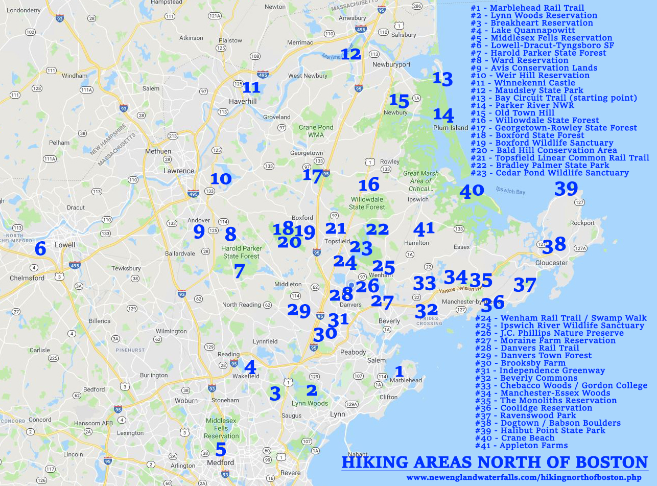
NORTH OF BOSTON HIKING AREA MAP
Here is a Google Map showing the general locations of each of the hiking areas that are listed in the table above.
TIPS FOR HIKING IN AREAS NORTH OF BOSTON
- BRING A MAP - most of the parks and hiking areas mentioned above do not all have a well-blazed or well-marked trail system. If you are used to hiking trails that have every junction well-marked with an obvious and intuitive trail sign, you may be surprised how infrequently you find that in this region. The good news is that most of these parks have trail maps that you can download on the internet (for free). In addition, you can also purchase the 2015 Bay Circuit Trail maps, which shows most trails in the region.
- BEWARE OF VEHICLE BREAK-INS - Don't leave anything valuable in your car. Although relatively rare in the heavily-populated Northeastern Massachusetts, break-ins do occur at trailheads from time to time.
- CARRY APPROPRIATE FOOD - Carry the appropriate type and amount of food based on the season you are hiking in (some foods will melt in summer, and some foods become rock-solid in winter) and the length of your hike.
- GET AN REI MEMBERSHIP - Purchase a $20 REI membership to save 8-10% on all full-price REI purchases for the rest of your life (you have no idea how much time you'll probably spend at their stores and on Rei.com). Also, strongly consider applying for the REI credit card (you can earn hundreds of dollars in dividends each year if you use this credit card as your primary card for your non-REI purchases).
- GET SOME ELECTROLYTES - Bring a sports drink (e.g. Gatorade) to get some electrolytes into your system. This is especially important on hot and humid days.
- BUGS - Bugs can be a real nuisance in this region throughout the entire warm-weather hiking season, although some days they are there, some days they are not. Common annoyances include: ticks (especially in spring), greenheads (near the ocean for a period of 2-3 weeks in summer typically), deer flies, and mosquitoes. You'll probably want to bring some DEET spray with you. And always check yourself for ticks after each hike.
- WINTER SEASON - trails are generally snow and ice free in Northeastern Massachusetts from April through November. In some years December can be snow and ice free as well. Most snow and ice is usually gone by early to mid March.
- ELEVATION GAIN - although there are no significant mountains in Northeastern Massachusetts, many trails have enough rocky ups and downs to make the trails seem much harder than they would appear based upon mileage.
- HIKING CROWDS - generally speaking, there are little or no crowds on the trails in this region. Enjoy the solitude!
- DOGS/PETS - although many of the parks above allow pets, many require them to be on-leash. A few select parks allow dogs off-leash or have a long-history of tolerating well-behaved dogs off-leash.
- THE TRUSTEES OF RESERVATION - become familiar with this outstanding non-profit conservation organization. They have more than 100 conservation properties across the state of Massachusetts, many of which offer fantastic hiking trails. There are a half-dozen or so of these reservations that are located north of Boston that offer great hiking trails. Take note that a growing number of their properties now include a parking fee (which usually take credit card).

Crane Beach, Ipswich
TOP TEN PLACES TO HIKE NORTH OF BOSTON
Here are my top ten favorite places to hike north of Boston:
- AVIS Conservation Lands (there are many AVIS properties in the town of Andover, and some are interconnected)
- Bay Circuit Trail (this 230-mile long trail from Plum Island to the South Shore is one of the finest semi-urban paths in the U.S.)
- Dogtown
- Harold Parker State Forest
- Ipswich River Wildlife Sanctuary
- Lynn Woods Reservation
- Middlesex Fells Reservation
- Ravenswood Park
- Ward Reservation
- Willowdale State Forest

Babson Boulders, Dogtown, Gloucester

Skull Rock, Lynn Woods Reservation, Lynn

Bradley Palmer State Park, Topsfield

Crane Beach, Ipswich

Halibut Point State Park, Rockport

J.C. Phillips Nature Preserve, Wenham

Babson Boulders, Dogtown, Gloucester

Dungeon Rock, Lynn Woods Reservation, Lynn

bridge over the Ipswich River, Bradley Palmer State Park, Topsfield

Appleton Farms, Hamilton

Babson Boulders, Dogtown, Gloucester

walking the Bay Circuit Trail in Hamilton

Halibut Point State Park, Rockport

Stone Tower, Lynn Woods Reservation, Lynn

Holt Hill, Ward Reservation, Andover

Danvers Rail Trail, Danvers
HELPFUL LINKS
Here are some helpful links that relate to hiking trails north of Boston:
- Bay Circuit Trail & Greenway = link
- Essex County Trail Association = link
- Manchester-Essex Conservation Trust = link
- Massachusetts Audubon Society = link
- Massachusetts State Parks = link
- The Trustees of Reservations = link
- Town of Andover: AVIS = link
HIKING COMMUNITIES ON FACEBOOK
If you enjoy hiking or backpacking in Massachusetts, I recommend that you strongly consider joining some or all of these groups on Facebook. Once accepted into the groups, please share your photos and adventures of hiking and backpacking throughout Massachusetts:
Connecticut / Maine / Massachusetts / New Hampshire / Rhode Island / Vermont
Home Page / About the Book / Book Updates / Top 40 Waterfalls / Swimming Holes / How To Use This Guide / Contact Us
Waterfall Photography / Top 25 New England Hikes / 4000 Footers of NH / Bigroads.com
© newenglandwaterfalls.com
photographs/images may not be used without permission
| Waterfalls, swimming holes, and hiking can be extremely dangerous. Hundreds of people have been injured or killed in the waterfalls and swimming holes of New England over the years. Never swim in strong water currents. Don't jump into a swimming hole without scouting it first. Do not climb up or along the side of waterfalls. Be wary of slippery rocks. Never swim in pools above waterfalls. Use of this website and all of its information is at your own risk! Newenglandwaterfalls.com will not be held liable for your actions. Be safe out there - and always use common sense! As an Amazon Associates affiliate, this website contains affiliate links. If you choose to purchase any products after clicking any links, I may receive a commission at no extra cost to you. I only endorse products that I have personally used or come highly recommended by trusted peers. |