The 48 4000-Footers of New Hampshire
Welcome to the Newenglandwaterfalls.com guide to hiking the 4,000 footers of New Hampshire!
New Hampshire has 48 mountains that exceed 4,000 feet in elevation, and at any point in time, thousands of hikers are working towards a goal of climbing them all. Most hikers will take several years (or sometimes decades) to accomplish this goal; for others, they may blitz through the list and finish it in a year or even less in some instances.
Each of the 4000-footers has at least one well-established trail to its summit. Most of the 4000-footers offer several different routes. The views on or near the summits of the the majority of the 4,000 footers are excellent. Fewer than ten of these peaks offer limited views or no views.
The 4000-footers of NH can be DANGEROUS. Many of the peaks require above-treeline travel, which exposes you to the elements. Hikers must always be prepared for the possibility of poor weather, especially from October through May. Hiking from October to May is considered winter hiking, and hikers must be fulled prepared for winter condition. Hundreds of hikers have been injured or killed over the years in these mountains. The challenge of the 4000-footers and the potential for poor weather (especially from Oct-May) must not be underestimated.
If you are going to hike the NH 4000-footers, I highly recommend purchasing these three excellent guidebooks from Amazon.com (affiliate links):
AMC White Mountain Guide (31st edition)
4000-Footers of the White Mountains (3rd edition)
Climbing New Hampshire's 48 4,000 Footers (1st edition)
The chart presented below displays summary characteristics of each of the 4000-footers. Please keep in mind that when a mountain is listed as fun & relatively safe for beginners, the mountain can still be very challenging or even flat out dangerous in poor weather conditions. If you don't have much experience climbing major mountains, you may find these peaks tougher than has been indicated below. A '10' in difficulty does not mean that the mountain is impossible; it just means that the mountain is very challenging and that new hikers (and their pets) may struggle with them. Folks are encouraged to hike the easier mountains first and, while doing so, you'll work towards obtaining the skills and physical fitness necessary to conquer the tougher and bigger peaks.
If you are looking to hike these mountains during the WINTER season, visit my Hiking the 4000-Footers in Winter page. And once you finish the 4000-footers, it is only natural to consider hiking New Hampshire's wonderful 52 With-a-View ('52WAV') list and/or the challenging Terrifying 25 ('T25') list.
Follow New England Waterfalls on Facebook! 
MOUNTAIN / PEAK
 = click for photographs = click for photographs |
LEVEL OF DIFFICULTY
(of the easiest route; see section below for route list) |
SCENIC / VIEW
RATING |
OTHER 4000-FOOTERS THAT ARE COMMONLY HIKED WITH THIS PEAK |
IS THIS MOUNTAIN
FUN & RELATIVELY SAFE FOR BEGINNERS? |
TRAIL INFO |
ADAMS
(5,774 feet) |
10
(extremely difficult) |
OUTSTANDING |
MADISON
JEFFERSON |
NO
(too difficult) |
trail info |
BOND
(4,698 feet) |
10
(extremely difficult) |
OUTSTANDING |
WEST BOND
BONDCLIFF
ZEALAND |
NO
(too difficult) |
trail info |
BONDCLIFF
(4,265 feet) |
10
(extremely difficult) |
OUTSTANDING |
BOND
WEST BOND
ZEALAND |
NO
(too difficult) |
trail info |
CABOT
(4,170 feet) |
7
(moderate) |
FAIR/GOOD
(however, 'The Horn' is nearby and has decent views) |
n/a - none |
NO
(lack of impressive views) |
trail info |
CANNON
(4,100 feet) |
7
(moderate) |
EXCELLENT |
n/a - none |
**YES** |
trail info |
CARRIGAIN
(4,700 feet) |
8
(difficult) |
OUTSTANDING
(from summit & Signal Ridge) |
n/a - none |
NO
(too difficult) |
trail info |
CARTER DOME
(4,832 feet) |
8
(difficult) |
EXCELLENT
(from nearby Mt. Hight) |
SOUTH CARTER
MIDDLE CARTER |
NO
(too difficult) |
trail info |
CARTER, MIDDLE
(4,610 feet) |
8
(difficult) |
GOOD
(from nearby ledges) |
SOUTH CARTER
CARTER DOME |
NO
(lack of impressive views) |
trail info |
CARTER, SOUTH
(4,430 feet) |
8
(difficult) |
POOR |
MIDDLE CARTER
CARTER DOME |
NO
(lack of impressive views) |
trail info |
EISENHOWER
(4,780 feet) |
6
(moderate) |
EXCELLENT |
PIERCE |
**YES**
(but avoid in poor weather) |
trail info |
FIELD
(4,340 feet) |
6
(moderate) |
FAIR/GOOD |
TOM
WILLEY |
NO
(lack of impressive views) |
trail info |
FLUME
(4,328 feet) |
8
(difficult) |
EXCELLENT |
LIBERTY |
NO
(too difficult) |
trail info |
GALEHEAD
(4,024 feet) |
7
(moderate) |
GOOD
(from nearby AMC Galehead Hut) |
SOUTH TWIN
NORTH TWIN
GARFIELD |
NO
(too difficult) |
trail info |
GARFIELD
(4,500 feet) |
6
(moderate) |
OUTSTANDING |
GALEHEAD |
**YES** |
trail info |
HALE
(4,054 feet) |
5
(moderate) |
POOR |
n/a - none |
NO
(lack of impressive views) |
trail info |
HANCOCK
(4,420 feet) |
7
(moderate) |
FAIR |
SOUTH HANCOCK |
NO
(lack of impressive views) |
trail info |
HANCOCK, SOUTH
(4,319 feet) |
7
(moderate) |
FAIR |
HANCOCK |
NO
(lack of impressive views) |
trail info |
ISOLATION
(4,004 feet) |
9
(very difficult) |
GOOD/GREAT |
n/a - none |
NO
(too difficult) |
trail info |
JACKSON
(4,052 feet) |
7
(moderate) |
GOOD/GREAT |
PIERCE |
**YES**
(but avoid in poor weather) |
trail info |
JEFFERSON
(5,712 feet) |
8
(difficult) |
OUTSTANDING |
WASHINGTON |
NO
(too difficult) |
trail info |
KINSMAN, NORTH
(4,293 feet) |
8
(difficult) |
GOOD
(from nearby ledge) |
SOUTH KINSMAN |
NO
(too difficult) |
trail info |
KINSMAN, SOUTH
(4,358 feet) |
8
(difficult) |
FAIR/GOOD |
NORTH KINSMAN |
NO
(too difficult) |
trail info |
LAFAYETTE
(5,260 feet) |
9
(very difficult) |
OUTSTANDING |
LINCOLN |
NO
(too difficult) |
trail info |
LIBERTY
(4,459 feet) |
8
(difficult) |
EXCELLENT |
FLUME |
NO
(too difficult) |
trail info |
LINCOLN
(5,089 feet) |
9
(very difficult) |
OUTSTANDING |
LAFAYETTE |
NO
(too difficult) |
trail info |
MADISON
(5,367 feet) |
9
(very difficult) |
OUTSTANDING |
ADAMS |
NO
(too difficult) |
trail info |
MONROE
(5,384 feet) |
8
(difficult) |
OUTSTANDING |
WASHINGTON |
NO
(too difficult) |
trail info |
MOOSILAUKE
(4,802 feet) |
7
(moderate) |
EXCELLENT |
n/a - none |
**YES**
(but avoid in poor weather) |
trail info |
MORIAH
(4,049 feet) |
8
(difficult) |
GREAT |
n/a - none |
NO
(too difficult) |
trail info |
OSCEOLA
(4,340 feet) |
5
(moderate) |
EXCELLENT |
EAST OSCEOLA |
**YES**
(take the trail from Tripoli Rd) |
trail info |
OSCEOLA, EAST
(4,156 feet) |
8
(difficult) |
POOR |
OSCEOLA |
NO
(lack of impressive views) |
trail info |
OWLS HEAD
(4,025 feet) |
9
(very difficult) |
FAIR
(from slide path en route) |
n/a - none |
NO
(too difficult) |
trail info |
PASSACONAWAY
(4,043 feet) |
7
(moderate) |
GOOD/GREAT
(best view from 0.3 mile spur) |
WHITEFACE |
NO
(too difficult) |
trail info |
PIERCE
(4,310 feet) |
5
(moderate) |
GREAT |
JACKSON
EISENHOWER |
**YES**
(but avoid in poor weather) |
trail info |
TECUMSEH
(4,003 feet) |
5
(moderate) |
GOOD/GREAT |
n/a - none |
**YES**
(via either Waterville Valley or Tripoli Road trailheads) |
trail info |
TOM
(4,051 feet) |
5
(moderate) |
FAIR |
FIELD
WILLEY |
NO
(lack of impressive views) |
trail info |
TRIPYRAMID, MIDDLE
(4,140 feet) |
8
(difficult) |
POOR/FAIR |
NORTH TRIPYRAMID |
NO
(lack of impressive views) |
trail info |
TRIPYRAMID, NORTH
(4,180 feet) |
8
(difficult) |
FAIR |
MIDDLE TRIPYRAMID |
NO
(lack of impressive views) |
trail info |
TWIN, NORTH
(4,761 feet) |
7
(moderate) |
EXCELLENT |
SOUTH TWIN
GALEHEAD |
NO
(too difficult) |
trail info |
TWIN, SOUTH
(4,902 feet) |
8
(difficult) |
EXCELLENT |
NORTH TWIN
GALEHEAD |
NO
(too difficult) |
trail info |
WASHINGTON
(6,288 feet) |
10
(extremely difficult) |
OUTSTANDING |
MONROE
JEFFERSON |
NO
(too difficult) |
trail info |
WAUMBEK
(4,006 feet) |
6
(moderate) |
GOOD
(from Starr King & an outlook 0.1 mile past the summit) |
n/a - none |
**YES** |
trail info |
WEST BOND
(4,540 feet) |
10
(extremely difficult) |
OUTSTANDING |
BOND
BONDCLIFF
ZEALAND |
NO
(too difficult) |
trail info |
WHITEFACE
(4,020 feet) |
8
(difficult) |
GREAT/EXCELLENT
(from nearby ledges) |
PASSACONAWAY |
**YES**
(although some moderate rock scrambling is required) |
trail info |
WILDCAT
(4,422 feet) |
9
(very difficult) |
GOOD/GREAT
(from nearby outlooks/ski area) |
WILDCAT "D" PEAK |
NO
(too difficult) |
trail info |
WILDCAT, PEAK D
(4,050 feet) |
9
(very difficult) |
GOOD/GREAT
(from nearby outlooks/ski area) |
WILDCAT |
NO
(too difficult) |
trail info |
WILLEY
(4,285 feet) |
8
(difficult) |
FAIR/GOOD |
TOM
FIELD |
NO
(lack of impressive views) |
trail info |
ZEALAND
(4,260 feet) |
8
(difficult) |
POOR
(however, Zeacliff is nearby and has outstanding views) |
BOND
WEST BOND
BONDCLIFF |
NO
(too difficult) |
trail info |
TIPS FOR HIKING THE NH 4000-FOOTERS
Here is a list of tips on how to safely enjoy hiking the 4000-footers. Please take a read before taking your first 4,000-footer hike...
- GUIDEBOOKS - Buy the 4000-Footers of the White Mountains (3rd Edition) and/or AMC White Mountain Guide (31st edition) guidebooks and actually read each relevant chapter before you hike each peak. You can purchase these books on Amazon.com or in-person at the excellent The Mountain Wanderer bookstore on NH-112/Kancamagus Highway in Lincoln, New Hampshire.
- TRAIL CONDITIONS - Use trailsnh.com and newenglandtrailconditions.com to obtain the latest in trail conditions, especially in winter and early spring, where trail conditions can be highly variable. Trailsnh.com is my favorite site since it aggregates trail conditions from many different websites.
- BLUEBIRD DAYS - Hike the best mountains on the beautiful 'bluebird' days, and the less interesting mountains on the overcast, rainy, or poor-weather days.
- BRING FRIENDS - Bring friends with you as you complete this journey, so long as you sincerely believe they will be capable of hiking these mountains and will actually enjoy the peak(s) that you are selecting for them on each hike.
- SNOWSHOEING - Try snowshoeing a 4000-footer when winter conditions are favorable, which typically means a base of at least 18-24 inches of snow. Waumbek, Tecumseh, and Tom are excellent choices for your first 4000-footer snowshoeing adventure.
- FACEBOOK GROUPS - Join one or several of the Facebook groups that are focused on the 4000-footers. You'll be inspired by others and it will help you keep abreast of trail conditions.
- YOUR FINAL PEAK - Start thinking about which mountain you want to finish your list on so that you can complete this journey on a truly great peak (and perhaps not on Owl's Head like so many others have done before you).
- HIGHER SUMMITS FORECAST - Check the Mount Washington Observatory Higher Summits Forecast the morning before each hike. The forecast usually gets updated on their website between 4:00-6:00 a.m. each morning.
- GO BACKPACKING - Climb at least one of the 4,000-foot peaks as part of a backpacking adventure (there are many backpacking opportunities in New Hampshire).
- CARRY THE 10 ESSENTIALS - Make sure to always hike with all 10 of the '10 Essentials'. For example, a headlamp can save your life if it gets dark sooner than you expected. In addition to the 10 essentials, I highly recommend carrying a whistle.
- STAY IN A HUT - Consider staying in an AMC hut or RMC hut or shelter at least once. The AMC huts are much cheaper in winter and also for a short time period during the spring and fall 'shoulder' seasons.
- HIKE OTHER MOUNTAINS - Take an occasional break from hiking the 4000-footers and hike other awesome mountains in New Hampshire, such as: Cardigan, Major, Pine, Middle Sugarloaf, Monadnock, Willard, Sandwich Dome, the Baldfaces, and Chocorua.
- ADD YOUR ACCOMPLISHMENT TO YOUR RESUME - When you finish climbing the 4,000 footers, add the feat to your CV / resume and perhaps also mention it on LinkedIn. Having this on your resume shows recruiters that you are strong-willed / determined / goal-focused.
- NEW ENGLAND 4,000-FOOTERS - Don't forget that Maine and Vermont have many of their own amazing 4000-footers that you should try to hike at some point. Katahdin in Maine is widely considered the finest mountain climb in the East. Once you finish all the 4,000-footers in New England, there are many more to be found in New York.
- USE TREKKING POLES - Save your knees and ankles over the long-term by using trekking poles on all significant hikes. Trekking poles will also help you cross streams and may also help you avoid some falls.
- LEAVE A NOTE - Always leave a note or tell someone which mountain and trails you will be hiking. Too many people are getting lost and/or injured in these mountains these days.
- BREAK-INS - Don't leave anything valuable in your vehicle (too many break-ins have been occurring, unfortunately). Some hikers will leave their vehicle doors open so that thieves don't break their windows (the idea is that thieves open your vehicle, see nothing inside it, and move on to the next vehicle).
- GET CREATIVE WITH YOUR HIKING ROUTES - Get creative with your hiking routes by taking advantage of hitch-hiking, using a car-spot, and/or mountain biking between trailheads. Remember, a traverse is usually much more interesting than an out-and-back hike. Study hiking maps carefully and read the trail descriptions in the AMC White Mountain Guide (31st edition) to help you select trails.
- POOR HIKING CONDITIONS - Many hikers prefer to avoid hiking the 4,000 footers from April 1st to May 15th and also from mid-October through the end of December. The trail conditions are usually not favorable due to snow 'monorails', heavy mud, and/or ice.
- BEAT THE CROWDS - If you start your hikes early (i.e. before 6:30-7:00am), you can find the best parking, beat most of the crowds to the summit, and maybe even catch a sunset or early morning cloud undercast.
- SEPTEMBER HIKING - Mid-week hiking in September after Labor Day is typically much quieter and the weather is often fantastic. Hike a 4000-footer at least once during this time-frame.
- GET INVOLVED IN TRAIL MAINTENANCE - One of the most rewarding things you can do in the White Mountains is to enroll as a trail adopter. You'll meet like-minded people and experience the satisfaction of a job well done when you do trail maintenance.
- HELP OTHERS FINISH THEIR LIST - Once you finish the 48, help other friends and family finish their 48 list. You may find that the second time around with others is more fun than the first.
- 4000-FOOTERS IN WINTER - If the 'all-season' 48 list wasn't challenging enough for you (or you are ready for the next challenge), hike the 48 during the winter season (it's far more difficult with a higher danger factor).
- FLAGS ON THE 48 - Do at least one peak during the annual Flags on the 48 event (better yet, finish your list during the event). This annual event has been going strong since 2002.
- BE CAREFUL WITH YOUR FOOD - Carry the appropriate food based on the temperatures you are hiking in (some foods will melt in summer, while other foods become rock-solid in winter).
- PLEASE DON'T BUILD CAIRNS - Please do not build new cairns or expand existing ones. The U.S. Forest Service and its passionate trail adopters have been specifically trained on when and where cairns should be placed. Adding new cairns or increasing the size of existing ones can cause hikers to get confused.
- REFUEL - Enjoy some burgers and beers (or some other indulgence if those aren't your thing) after at least some of your hikes. Two excellent and very popular restaurants are Woodstock Inn Station & Brewery in Lincoln and Moat Mountain Smoke House & Brewing Company in North Conway.
- ROCK SCRAMBLES - Consider hiking some of the optional but extremely fun rock scrambles along your journey (Caps Ridge Trail on Jefferson, Flume Slide Trail on Flume, Wildcat Ridge Trail on the Wildcats, and the North Slide of North Tripyramid come to mind).
- THE MOUNTAIN WANDERER - Introduce yourself to Steve Smith at the Mountain Wanderer bookstore in Lincoln, New Hampshire at some point in your journey. There aren't many people as passionate about these mountains as he is. He has hiked every trail in the White Mountains, so if you have a question about a particular trail, he's going to have an answer for you.
- DON'T DRED OWL'S HEAD - Don't dread Owl's Head too much. It's not that bad, plus there are actually some decent views on the slide.
- GET AN REI MEMBERSHIP - If you are reading this list, it is likely you already have a lifetime REI membership. But if you don't, spend $20 to buy yourself one. This membership will earn you a 8-10% dividend on all full-price REI purchases for the rest of your life. To save even more, get the REI credit card and use it for all your REI and non-REI purchases (the dividend dollars will add up very quickly).
- FALL FOLIAGE - Don't miss hiking at least one of the better mountains during peak fall foliage. Mt. Garfield is one of the best 4000-footers to hike during peak fall foliage. Fall foliage is typically at peak during the first two weeks of October.
- ELECTROLYTES - Enjoy that Gatorade or Powerade drink to keep your electrolyte levels up. You'll be amazed how much of an energy boost these drinks can give some people. Single-serve powder packets are perhaps the most useful since they allow you to make your drink when you are ready for it.
- DEATH MARCHES - Contemplate a challenging one-day traverse, like the Bonds Traverse or a Presidential Traverse. Other death marches include the Wildcat-to-Moriah Traverse, the Kinsman Ridge Traverse, and the infamous Pemi Loop. Don't underestimate the difficulty of these ultra-hikes; always factor in a mid-point bail out plan if things aren't going well.
- KEEP A LOGBOOK - Keep a journal or at least keep a logbook of the order, dates, and hiking partners that joined you for each of the peaks. You may be thankful you did this later on as you make progress towards finishing the list.
- VITAMIN I - Ibuprofen can be extremely helpful in controlling knee or ankle pain and/or reducing swelling. Don't overuse it though.
- ATTEND THE AMC AWARDS CEREMONY - After you finish hiking all 48, you can elect to fill out an AMC application and attend an annual hikers' award ceremony.
- BAD WEATHER - Be safe out there: these mountains can be nasty (even deadly) in adverse weather conditions. Snow and ice can also be very problematic, even into May or June on some peaks. Snow and/or ice starts hitting most peaks in October, although some of the tallest mountains can experience snow and/or ice sooner than this.
- TRY GOING SOLO - Trying hiking at least one peak solo. It's an entirely different experience, and many will find it refreshing. For those who have fears about hiking solo, consider whether those fears are truly justified or not (i.e. you are not going to be attacked by a bear).
- MEETUP.COM OR FACEBOOK GROUPS - If you are short on hiking friends, consider joining a Meetup or Facebook hiking group. There are always some New Hampshire hikes planned. You probably won't like everyone you meet, but if you do a few of these, you can make some connections and just hike with those specific people in the future.
- GEAR STORES - Spend time perusing at least a few gear stores that focus on hiking & backpacking equipment. REI is my top choice, but there are others like EMS and LL Bean.
- FIRST AID COURSE - Take a wilderness first aid course to prepare you in case something goes wrong, either with you or a member of your hiking party. At a minimum, learn CPR and how to make a splint.
- GET GOOD AT PREDICTING THE WEATHER - Try to read the weather frequently while hiking, and react quickly to changes in clouds and wind direction. Look for gather clouds, thunder clouds and increases in wind speed.
- CATCH A SUNRISE OR SUNSET - Catch a sunset or sunrise from above treeline if you can. Bring at least one headlamp with fresh batteries to assist you in getting up or down. For best lighting conditions, try to arrive at least 30-45 minutes before sunrise or sunset.
- WMNF ROAD STATUS - Keep abreast as to which roads in the White Mountain National Forest roads are currently closed. The rangers maintain a road status log here (although it is not always updated timely).
- 4000 FOOTER PASSBOOK - Record your hikes in a beautiful little journal specifically made to track your progress towards hiking all of the 4000-footers. There's also one of these journals for hiking the 52 With-A-View, which is another highly rewarding hiking list.
- MORE HIKING LISTS - Many hikers will hike these peaks over and over and over again after they initially finish the 4,000 footers list. While that's totally fine and dandy, there are many other great hiking lists in New England, such as the NH 52 With-A-View, The Terrifying 25, and the New England 67.
- BLACK FLIES - Black flies and other bugs can be a real nuisance in this region from mid-May through early July, although some days they are there, some days they are not. You'll probably want to bring some DEET spray with you, and maybe a wide-brimmed hat and bug net. I personally recommend using 100% DEET, although some bugs may still bite.
- TRIP REPORTS & GEAR REVIEWS - Phillip Werner has many 4,000 footer trip reports and also tons of gear reviews on his website, sectionhiker.com.
- BRING $5.00 CASH TO PARK - many of the most popular trailheads in the White Mountain National Forest require a $5.00 parking fee, which must be paid in CASH at a self-service kiosk. You can also buy an annual pass from one of the ranger districts or select retailers in the region. If you have an annual national parks pass, it will cover these parking fees (leave the pass on your dashboard).

hiking towards Mt. Lincoln on the Franconia Ridge Trail
STANDARD HIKING ROUTES TO THE 4000-FOOTERS
Presented below are the most common routes used to hike each of the 4000-footers in the non-winter seasons, along with their total mileage and elevation gain. Before you hike these routes, take note that many of these peaks offer one (or many) alternate trails, some of which offer better scenery and/or fewer crowds than the most common route. If you want to know the standard hiking routes in winter, read my 4000-Footers in Winter guide.
- ADAMS = there are many popular ways to hike or backpack this mountain, and so there's really no standard route. Here's one popular, fun and extremely scenic option: Appalachia/US 2 trailhead > Air Line Trail > summit > Air Line Trail > Gulfside Trail > Valley Way Trail > end
---------------------------------------------------------------------------------------------------------------------------------------------
- BOND = this mountain is typically hiked or backpacked via a north-to-south or south-to-north 'Bonds Traverse' that includes four 4,000-footers. Here is the slightly more popular north-to-south version: trailhead at the end of Zealand Road > Zealand Trail > Twinway > Zealand Spur Trail > Zealand summit > Zealand Spur Trail > Twinway > Bondcliff Trail > West Bond Spur Trail > West Bond summit > West Bond Spur Trail > Bondcliff Trail > Mt. Bond summit > Bondcliff Trail > Bondcliff summit > Bondcliff Trail > Wilderness Trail > Lincoln Woods Trail > NH 112/Kancamagus Highway trailhead > end
---------------------------------------------------------------------------------------------------------------------------------------------
- BONDCLIFF = this mountain is typically hiked or backpacked via a north-to-south or south-to-north 'Bonds Traverse' that includes four 4,000-footers. Here is the slightly more popular north-to-south version: trailhead at the end of Zealand Road > Zealand Trail > Twinway > Zealand Spur Trail > Zealand summit > Zealand Spur Trail > Twinway > Bondcliff Trail > West Bond Spur Trail > West Bond summit > West Bond Spur Trail > Bondcliff Trail > Mt. Bond summit > Bondcliff Trail > Bondcliff summit > Bondcliff Trail > Wilderness Trail > Lincoln Woods Trail > NH 112/Kancamagus Highway trailhead > end
---------------------------------------------------------------------------------------------------------------------------------------------
- CABOT = York Pond Road trailhead > York Pond Trail > Bunnell Notch Trail > Mt. Cabot Trail > summit
---------------------------------------------------------------------------------------------------------------------------------------------
- CANNON = there are several popular ways to climb this mountain, and so there's really no standard route. Here's one popular & fun option: Lafayette Campground/I-93 trailhead > Lonesome Lake Trail > Hi-Cannon Trail > Kinsman Ridge Trail > summit > Kinsman Ridge Trail > Lonesome Lake Trail > end
---------------------------------------------------------------------------------------------------------------------------------------------
- CARRIGAIN = Sawyer Pond Road trailhead > Signal Ridge Trail > summit
---------------------------------------------------------------------------------------------------------------------------------------------
- CARTER DOME = NH 16 trailhead > Nineteen Mile Brook Trail > Carter Dome Trail > Carter-Moriah Trail > Mt. Hight summit > Carter-Moriah Trail > Carter Dome summit
---------------------------------------------------------------------------------------------------------------------------------------------
- CARTER, MIDDLE = there are several popular ways to climb this mountain, and so there's really no standard route. Here's one popular option that climbs both of the Carters in one trip: NH 16 trailhead > Nineteen Mile Brook Trail > Carter Dome Trail > Carter-Moriah Trail > South Carter summit > Carter-Moriah Trail > Middle Carter summit > Carter-Moriah Trail > North Carter Trail > Imp Trail (northern segment) > The Imp viewpoint > Imp Trail (northern segment) > NH 16 > road walk heading south > end
---------------------------------------------------------------------------------------------------------------------------------------------
- CARTER, SOUTH = there are several popular ways to climb this mountain, and so there's really no standard route. Here's one popular option that climbs both of the Carters in one trip: NH 16 trailhead > Nineteen Mile Brook Trail > Carter Dome Trail > Carter-Moriah Trail > South Carter summit > Carter-Moriah Trail > Middle Carter summit > Carter-Moriah Trail > North Carter Trail > Imp Trail (northern segment) > The Imp viewpoint > Imp Trail (northern segment) > NH 16 > road walk heading south > end
---------------------------------------------------------------------------------------------------------------------------------------------
- EISENHOWER = Mt. Clinton Road trailhead > Edmands Path > Mt. Eisenhower Loop > summit
---------------------------------------------------------------------------------------------------------------------------------------------
- FIELD = most people will try to hike all three peaks in the Willey Range in one day by following this route: US 302 trailhead > Avalon Trail > A-Z Trail > Mt. Tom Spur > Mt. Tom summit > Mt. Tom Spur > Willey Range Trail > Mt. Field summit > Willey Range Trail > Mt. Willey summit > Willey Range Trail > Mt. Field summit (again) > Avalon Trail > Mt. Avalon Spur Trail > Mt. Avalon summit > Mt. Avalon Spur Trail > Avalon Trail > end
---------------------------------------------------------------------------------------------------------------------------------------------
- FLUME = there are several popular ways to climb this mountain, and so there's really no standard route. Here's one popular & fun option if you want to also climb Mt. Liberty and you don't mind some steep scrambling: Flume Visitor Center trailhead > Whitehouse Trail or Franconia Notch Recreational Trail (Bike Path) > Liberty Spring Trail > Flume Slide Trail > Franconia Ridge Trail > Mt. Flume summit > Franconia Ridge Trail > Mt. Liberty summit > Franconia Ridge Trail > Liberty Spring Trail >Whitehouse Trail or Franconia Notch Recreational Trail (Bike Path) > end
---------------------------------------------------------------------------------------------------------------------------------------------
- GALEHEAD = Gale River Loop Road trailhead > Gale River Trail > Garfield Ridge Trail > AMC Galehead Hut > Frost Trail > summit
---------------------------------------------------------------------------------------------------------------------------------------------
- GARFIELD = Gale River Loop Road trailhead > Mt. Garfield Trail > Garfield Ridge Trail > summit
---------------------------------------------------------------------------------------------------------------------------------------------
- HALE = Zealand Road trailhead > Hale Brook Trail > summit
---------------------------------------------------------------------------------------------------------------------------------------------
- HANCOCK = Both Hancock and South Hancock are typically hiked together: NH 112/Kancamagus Highway trailhead > Hancock Notch Trail > Cedar Brook Trail > Hancock Loop Trail > South Hancock summit > Hancock Loop Trail > Hancock summit > Hancock Loop Trail > Cedar Brook Trail > Hancock Notch Trail > end
---------------------------------------------------------------------------------------------------------------------------------------------
- HANCOCK, SOUTH = Both Hancock and South Hancock are typically hiked together: NH 112/Kancamagus Highway trailhead > Hancock Notch Trail > Cedar Brook Trail > Hancock Loop Trail > South Hancock summit > Hancock Loop Trail > Hancock summit > Hancock Loop Trail > Cedar Brook Trail > Hancock Notch Trail > end
---------------------------------------------------------------------------------------------------------------------------------------------
- ISOLATION = there are several popular ways to climb this mountain, and so there's really no standard route. Here's one popular & fun option that will get you above treeline for a while if you have two vehicles: Glen Ellis Falls/NH 16 trailhead > Glen Boulder Trail > Davis Path > Spur Trail > Mt. Isolation summit > Spur Trail > Davis Path > Isolation Trail > Rocky Branch Trail > Road walk > End
---------------------------------------------------------------------------------------------------------------------------------------------
- JACKSON = US 302 trailhead > Webster-Jackson (Jackson Branch) > summit
---------------------------------------------------------------------------------------------------------------------------------------------
- JEFFERSON = Jefferson Notch Road trailhead > Caps Ridge Trail > summit
---------------------------------------------------------------------------------------------------------------------------------------------
- KINSMAN, NORTH = nearly all hikers will climb both Kinsmans together. Here's the preferred route: NH 116 trailhead > Mt. Kinsman Trail > Kinsman Ridge Trail > North Kinsman summit > Kinsman Ridge Trail > South Kinsman summit
---------------------------------------------------------------------------------------------------------------------------------------------
- KINSMAN, SOUTH = nearly all hikers will climb both Kinsmans together. Here's the preferred route: NH 116 trailhead > Mt. Kinsman Trail > Kinsman Ridge Trail > North Kinsman summit > Kinsman Ridge Trail > South Kinsman summit
---------------------------------------------------------------------------------------------------------------------------------------------
- LAFAYETTE = most hikers will try to climb both Lafayette and Lincoln in one trip: I-93 trailhead > Falling Waters Trail > Franconia Ridge Trail > Mt. Lincoln summit
> Franconia Ridge Trail > Mt. Lafayette summit
> Greenleaf Trail > Old Bridle Path > End
---------------------------------------------------------------------------------------------------------------------------------------------
- LIBERTY = there are several popular ways to climb this mountain, and so there's really no standard route. Here's one popular & fun option if you want to also climb Mt. Flume and you don't mind some steep scrambling: Flume Visitor Center trailhead > Whitehouse Trail or Franconia Notch Recreational Trail (Bike Path) > Liberty Spring Trail > Flume Slide Trail > Franconia Ridge Trail > Mt. Flume summit > Franconia Ridge Trail > Mt. Liberty summit > Franconia Ridge Trail > Liberty Spring Trail >Whitehouse Trail or Franconia Notch Recreational Trail (Bike Path) > end
---------------------------------------------------------------------------------------------------------------------------------------------
- LINCOLN= most hikers will try to climb both Lafayette and Lincoln in one trip: I-93 trailhead > Falling Waters Trail > Franconia Ridge Trail > Mt. Lincoln summit > Franconia Ridge Trail > Mt. Lafayette summit > Greenleaf Trail > Old Bridle Path > End
---------------------------------------------------------------------------------------------------------------------------------------------
- MADISON = there are several popular ways to climb this mountain, and so there's really no standard route. Here's one popular and fun option: Appalachia/US 2 trailhead > Airline Trail > Airline Cutoff > Osgood Trail > summit >
Osgood Trail > Valley Way > end
---------------------------------------------------------------------------------------------------------------------------------------------
- MONROE = Base Road trailhead > Ammonoosuc Ravine Trail > Crawford Path > Mt. Monroe Loop > summit
---------------------------------------------------------------------------------------------------------------------------------------------
- MOOSILAUKE = Moosilauke Ravine Lodge trailhead > Gorge Brook Trail > summit >
Moosilauke Carriage Road > Snapper Trail > end
---------------------------------------------------------------------------------------------------------------------------------------------
- MORIAH = NH 16 trailhead > Stony Brook Trail > Carter-Moriah Trail > summit
---------------------------------------------------------------------------------------------------------------------------------------------
- OSCEOLA = most hikers will hike both Osceola & East Osceola in one trip: Tripoli Road trailhead > Mt. Osceola Trail > Osceola summit > Mt. Osceola Trail > East Osceola summit
---------------------------------------------------------------------------------------------------------------------------------------------
- OSCEOLA, EAST = most hikers will hike both Osceola & East Osceola in one trip: Tripoli Road trailhead > Mt. Osceola Trail > Osceola summit > Mt. Osceola Trail > East Osceola summit
---------------------------------------------------------------------------------------------------------------------------------------------
- OWLS HEAD = NH 112/Kancamagus Highway trailhead (Lincoln Woods) > Lincoln Woods Trail > Franconia Brook Trail > Lincoln Brook Trail > Owl's Head Path > summit
---------------------------------------------------------------------------------------------------------------------------------------------
- PASSACONAWAY = many hikers will try to climb both Passaconaway & Whiteface in one trip: Ferncroft Road trailhead > Blueberry Ledge Trail > Rollins Trails > Whiteface summit > Rollins Trail > Dicey's Mill Trail > Passaconaway summit > Dicey's Mill Trail > end
---------------------------------------------------------------------------------------------------------------------------------------------
- PIERCE = Mt. Clinton Road trailhead > Crawford Connector Trail > Crawford Path > Webster Cliff Trail > summit
---------------------------------------------------------------------------------------------------------------------------------------------
- TECUMSEH = Waterville Valley Ski Resort trailhead > Mt. Tecumseh Trail > summit
---------------------------------------------------------------------------------------------------------------------------------------------
- TOM = most people will try to hike all three peaks in the Willey Range in one day by following this route: US 302 trailhead > Avalon Trail > A-Z Trail > Mt. Tom Spur > Mt. Tom summit > Mt. Tom Spur > Willey Range Trail > Mt. Field summit > Willey Range Trail > Mt. Willey summit > Willey Range Trail > Mt. Field summit (again) > Avalon Trail > Mt. Avalon Spur Trail > Mt. Avalon summit > Mt. Avalon Spur Trail > Avalon Trail > end
---------------------------------------------------------------------------------------------------------------------------------------------
- TRIPYRAMID, MIDDLE = there are several popular ways to climb this mountain, and so there's really no standard route. Here's one good loop option that bags both of the Tripyramids in one trip: NH 112/Kancamagus Highway trailhead > Pine Bend Brook Trail > North Tripyramid summit >
Mt. Tripyramid Trail > Middle Tripyramid summit >
Mt. Tripyramid Trail >
Sabbaday Brook Trail > road walk > end
---------------------------------------------------------------------------------------------------------------------------------------------
- TRIPYRAMID, NORTH = there are several popular ways to climb this mountain, and so there's really no standard route. Here's one good loop option that bags both of the Tripyramids in one trip: NH 112/Kancamagus Highway trailhead > Pine Bend Brook Trail > North Tripyramid summit >
Mt. Tripyramid Trail > Middle Tripyramid summit >
Mt. Tripyramid Trail >
Sabbaday Brook Trail > road walk > end
---------------------------------------------------------------------------------------------------------------------------------------------
- TWIN, NORTH = most people will try to hike both Twins in one day by following this route: Haystack Road trailhead > North Twin Trail > North Twin summit > North Twin Spur Trail > South Twin summit
---------------------------------------------------------------------------------------------------------------------------------------------
- TWIN, SOUTH = most people will try to hike both Twins in one day by following this route: Haystack Road trailhead > North Twin Trail > North Twin summit > North Twin Spur Trail > South Twin summit
---------------------------------------------------------------------------------------------------------------------------------------------
- WASHINGTON = there are several popular ways to climb this mountain, and so there's really no standard route. Here's one popular, challenging and extremely scenic option: AMC Pinkham Notch Center/NH 16 trailhead > Tuckerman Ravine Trail > summit
> Tuckerman Ravine Trail > Lion's Head Trail > Tuckerman Ravine Trail > end
---------------------------------------------------------------------------------------------------------------------------------------------
- WAUMBEK = Starr King Road/US 2 trailhead > Starr King Trail > Starr King summit > Starr King Trail > Mt. Waumbek summit
> viewpoint 0.1 mile past summit
---------------------------------------------------------------------------------------------------------------------------------------------
- WEST BOND = this mountain is typically hiked or backpacked via a north-to-south or south-to-north 'Bonds Traverse' that includes four 4,000-footers. Here is the slightly more popular north-to-south version: trailhead at the end of Zealand Road > Zealand Trail > Twinway > Zealand Spur Trail > Zealand summit > Zealand Spur Trail > Twinway > Bondcliff Trail > West Bond Spur Trail > West Bond summit > West Bond Spur Trail > Bondcliff Trail > Mt. Bond summit > Bondcliff Trail > Bondcliff summit > Bondcliff Trail > Wilderness Trail > Lincoln Woods Trail > NH 112/Kancamagus Highway trailhead > end
---------------------------------------------------------------------------------------------------------------------------------------------
- WHITEFACE = many hikers will try to climb both Passaconaway & Whiteface in one trip: Ferncroft Road trailhead > Blueberry Ledge Trail > Rollins Trails > Whiteface summit > Rollins Trail > Dicey's Mill Trail > Passaconaway summit > Dicey's Mill Trail > end
---------------------------------------------------------------------------------------------------------------------------------------------
- WILDCAT = many hikers will try to climb both Wildcat & Wildcat D in one trip by using two cars or by hitchhiking: Glen Ellis Falls/NH 16 trailhead > Wildcat Ridge Trail > Wildcat D summit >
Wildcat Ridge Trail > Wildcat summit >
Wildcat Ridge Trail > Nineteen-Mile Brook Trail > road walk (if two vehicles were not used) > end
- 8.5 mile loop plus road walk if two vehicles were not used; 3,150ft gain; very difficult
- Special Note: If the Ellis River is running high, you can cross at AMC Pinkham Notch visitor center and use Lost Pond Trail to connect with Wildcat Ridge Trail
- Full trail descriptions can be found in the AMC White Mountain Guide (31st edition)
---------------------------------------------------------------------------------------------------------------------------------------------
- WILDCAT, PEAK D = many hikers will try to climb both Wildcat & Wildcat D in one trip by using two cars or by hitchhiking: Glen Ellis Falls/NH 16 trailhead > Wildcat Ridge Trail > Wildcat D summit >
Wildcat Ridge Trail > Wildcat summit >
Wildcat Ridge Trail > Nineteen-Mile Brook Trail > road walk (if two vehicles were not used) > end
- 8.5 mile loop plus road walk if two vehicles were not used; 3,150ft gain; very difficult
- Special Note: If the Ellis River is running high, you can cross at AMC Pinkham Notch visitor center and use Lost Pond Trail to connect with Wildcat Ridge Trail
- Full trail descriptions can be found in the AMC White Mountain Guide (31st edition)
---------------------------------------------------------------------------------------------------------------------------------------------
- WILLEY = most people will try to hike all three peaks in the Willey Range in one day by following this route: US 302 trailhead > Avalon Trail > A-Z Trail > Mt. Tom Spur > Mt. Tom summit > Mt. Tom Spur > Willey Range Trail > Mt. Field summit > Willey Range Trail > Mt. Willey summit > Willey Range Trail > Mt. Field summit (again) > Avalon Trail > Mt. Avalon Spur Trail > Mt. Avalon summit > Mt. Avalon Spur Trail > Avalon Trail > end
---------------------------------------------------------------------------------------------------------------------------------------------
- ZEALAND = this mountain is typically hiked or backpacked via a north-to-south or south-to-north 'Bonds Traverse' that includes four 4,000-footers. Here is the slightly more popular north-to-south version: trailhead at the end of Zealand Road > Zealand Trail > Twinway > Zealand Spur Trail > Zealand summit > Zealand Spur Trail > Twinway > Bondcliff Trail > West Bond Spur Trail > West Bond summit > West Bond Spur Trail > Bondcliff Trail > Mt. Bond summit > Bondcliff Trail > Bondcliff summit > Bondcliff Trail > Wilderness Trail > Lincoln Woods Trail > NH 112/Kancamagus Highway trailhead > end
Take note that there are alternate hiking routes for most of the mountains listed above. Consult the AMC White Mountain Guide (31st edition) for detailed descriptions of ALL of the hiking routes that these peaks offer.
If you suspect there are any errors in the above information, please email gparsons66@hotmail.com so that it can be fixed.

summit of Mt. Eisenhower *prior* to the cairn being rebuilt
EASIEST 4000-FOOTERS
Here are the easiest 4000-footers to climb, along with the easiest routes on each of these mountains:
Cannon - via Lonesome Lake > Kinsman Ridge Trail or via Kinsman Ridge Trail (from the Cannon Mountain ski resort)
Eisenhower - via Edmands Path
Field - via Avalon Trail > Willey Range Trail
Garfield - via Mt. Garfield Trail > Garfield Ridge Trail
Hale - via Hale Brook Trail
Moosilauke - via Gorge Brook Trail > Carriage Road > Snapper Trail loop
Osceola - via Mt. Osceola Trail (from Tripoli Road)
Pierce - via Crawford Path
Tecumseh - via Mt. Tecumseh Trail (from the Waterville Valley ski resort)
Tom - via Avalon Trail > A-Z Trail > Mt. Tom Spur
Waumbek - via Starr King Trail; don't miss the great views 0.1 mile beyond the summit of Waumbek
The easiest of all 4000-footers to hike is Mt. Tecumseh via the Waterville Valley Ski Resort trailhead. This is a 5.0 mile round-trip hike with 2,300 feet of elevation gain. As the result of some illegal tree-cutting somewhere around 2014/2015, Mt. Tecumseh now offers great views.
The easiest way to climb two 4000-footers in just one hike is probably Tom & Field, However, if you only hike Tom & Field, you may end up regretting not also hiking nearby Willey while you are already elevated in that mountain range. North Hancock & South Hancock, and Jackson & Pierce are other pairs of peaks that are easily combined, although hiking them is by no means easy.

view of the Pemigewasset Wilderness from Mt. Garfield
MOST DIFFICULT 4000-FOOTERS
These 4000-footers are considered the most difficult. There are no easy trails that climb these tough peaks:
Adams - lots of elevation gain, and some sections of trail are extremely rocky; weather can be extremely nasty
Bond - extremely remote; requires a hike of at least 19 miles round trip
Bondcliff - remote; requires a hike of at least 18 miles round trip
Isolation - remote; trails are often very wet/muddy
Owl's Head - remote; requires a hike of at least 18 miles round trip; involves hiking up a steep slide that has some loose rock; water crossings can also be challenging in moderate to high water
Washington - lots of elevation gain; most trails are extremely rocky; the weather is often very nasty; generally snow/ice free for only a few months of the year
West Bond - extremely remote; requires a hike of at least 19 miles round trip
Wildcat & Wildcat D - all trails are steep and rocky

the classic shot of Bondcliff
4000-FOOTERS WITH THE BEST VIEWS
These 4000-footers will blow you away with their outstanding and completely unobstructed views:
Adams
Bond
Bondcliff
Carrigain
Eisenhower
Garfield
Jefferson
Lafayette
Liberty
Lincoln
Madison
Monroe
Moosilauke
Washington
West Bond
Of all of these peaks, my opinion is that the fire-tower atop Mt. Carrigain offers the finest view, especially in winter (which is a 14-mile hike in winter).

Star Lake with Mt. Madison in the background
FAVORITE 4000-FOOTERS
Here are my favorite 4000-footers, along with what makes them so great:
Bondcliff - wide-open, completely road-less views; awesome cliff-top photo-opportunity
Carrigain - the fire tower deck at the summit has perhaps the best view in the White Mountains; Signal Ridge is equally spectacular
Monroe - fantastic alpine views of Lakes of the Clouds and Lakes of the Clouds Hut, along with Mt. Washington
Lafayette - part of the incredible Franconia Ridge Trail; combine with Mt. Lincoln for an 8.9 mile loop
Lincoln - part of the incredible Franconia Ridge Trail; combine with Mt. Lafayette for an 8.9 mile loop
If I had to choose one favorite peak, it would be Carrigain on a perfectly clear winter day.

the view from Zeacliff, a quick and easy side trip on the way to Zealand Mountain
MOST POPULAR 4000-FOOTERS
It's tough to beat the crowds on these popular 4000-footers. I recommend hiking them mid-week or starting really early (before 7:00am) to beat the crowds:
Adams
Cannon
Carrigain
Eisenhower
Garfield
Jackson
Jefferson
Lafayette
Liberty
Lincoln
Madison
Monroe
Moosilauke
Osceola
Pierce
Washington
Whiteface

winter views of Mt. Washington from Signal Ridge on Mt. Carrigain
LEAST CROWDED 4000-FOOTERS
All of the 4000-footers see a fair amount of hiker traffic these days, but these peaks are generally considered to be the least crowded:
Cabot
Carter, Middle
Carter, South
Hale
Hancock
Hancock, South
Isolation
Moriah
Osceola, East
Owl's Head
Tripyramid, Middle
Tripyramid, North
Waumbek
Wildcat
Wildcat, D Peak
Willey

Mt. Liberty from the summit of Mt. Flume
UNOBSTRUCTED 360-DEGREE VIEWS AT THE SUMMIT
Nothing obscures the excellent 360-degree views from the top of these peaks:
Adams
Bond
Bondcliff
Cannon
Carrigain
Eisenhower
Flume
Garfield
Jackson
Jefferson
Lafayette
Liberty
Lincoln
Madison
Monroe
Moosilauke
Moriah
Twin, South
Washington
West Bond
Wildcat, D
BEST 4000-FOOTERS FOR RAINY DAYS
As long as the river crossings are not swollen, these 4,000-footers can make for good rainy-day hikes:
Cabot - the views are limited, so you aren't missing much if you hike this peak in the rain
Field - as long as the river crossings are expected to stay low enough; combine with two other 4,000 footers: Tom and Willey
Hale - the views are limited, so you aren't missing much if you hike this peak in the rain
Hancock - as long as the river crossings are expected to stay low enough
Hancock, South - as long as the river crossings are expected to stay low enough
Owl's Head - as long as the river crossings are expected to stay low enough or you take the Black Pond bushwhack route
Tom - as long as the river crossings are expected to stay low enough; combine with two other 4,000 footers: Field and Willey
Willey - as long as the river crossings are expected to stay low enough; combine with two other 4,000 footers: Field and Tom
In my opinion, the best 4,000-footers to hike in the rain are Cabot and Hale. These peaks don't really offer any great views, and there are no major river crossings to contend with either.
I would avoid hiking Carter Dome, Galehead, North Carter, South Carter, Tecumseh, Waumbek, or Zealand in the rain because they offer good views, either at the summits themselves and/or nearby. Save those peaks (and most others for that matter) for nicer weather days.
While many people hike the Hancocks, Owl's Head, and the Willey Range peaks (Tom/Field/Willey) in the rain, you have to be certain that the river crossings are not going to swell up to dangerous levels. This can be tough to predict if you aren't familiar with the watershed size of those areas.
WATERFALLS NEAR 4000-FOOTERS
You see see quite a few waterfalls along your journey to hike the 4000-footers, depending on the trails you select and the number of spur trails/detours you choose to take:
Adams - the various waterfalls of Appalachia (there are many of them, so refer to a detailed map to see them all)
Bond - Zealand Falls, Franconia Falls
Bondcliff - Zealand Falls, Franconia Falls
Jackson - unnamed falls above Silver Cascade
Jefferson - the various falls on several of the northern approach trails
Lafayette - the various falls along the Falling-Waters Trail (Stairs Falls, Swiftwater Falls, Cloudland Falls)
Lincoln - the various falls along the Falling-Waters Trail (Stairs Falls, Swiftwater Falls, Cloudland Fall
Madison - various falls of Appalachia (there are many of them, so refer to a detailed map to see them all)
Monroe - Gem Pool, Ammonoosuc Ravine
Owl's Head - Franconia Falls
Pierce - Gibbs Falls
Washington - Crystal Cascade, Weetamoo Falls, Ammonoosuc Ravine, Gem Pool, several others
West Bond - Zealand Falls, Franconia Falls
Zealand - Zealand Falls
GREAT 4000-FOOTER SNOWSHOE HIKES
These 4000-footers can make for an extremely enjoyable snowshoeing trek when the snow conditions are good:
Cabot
Carrigain - this is quite a long day-hike in winter because the normal access road is closed (this adds 4.0 miles round-trip)
Field
Garfield - this is quite a long day-hike in winter because the normal access road is closed (this adds 2.4 miles round-trip)
Hale
Kinsman, North - this is quite a long day-hike; hiking via the Mt. Kinsman Trail off NH 116 is recommended
Kinsman, South - this is quite a long day-hike; hiking via the Mt. Kinsman Trail off NH 116 is recommended
Passaconaway
Pierce
Tecumseh
Tom
Waumbek
Willey
I highly recommend checking alltrails.com and/or www.trailsnh.com for current trail conditions.
4000-FOOTERS TO AVOID IN POOR WEATHER
People hike the 4000-footers in all sorts of weather conditions, but many will prefer to avoid these peaks if storms or heavy wind are predicted:
Adams - this peak requires significant amounts of above-treeline hiking
Bond - this peak requires significant amounts of above-treeline hiking
Bondcliff - this peak requires significant amounts of above-treeline hiking
Eisenhower - this peak requires significant amounts of above-treeline hiking
Isolation - this peak is extremely remote and requires significant amounts of above treeline hiking if you approach via Glen Boulder
Jackson - this peak requires some above-treeline hiking
Jefferson - this peak requires significant amounts of above-treeline hiking
Lafayette - this peak requires significant amounts of above-treeline hiking
Lincoln - this peak requires significant amounts of above-treeline hiking
Madison - this peak requires significant amounts of above-treeline hiking
Monroe - this peak requires significant amounts of above-treeline hiking
Moosilauke - this peak requires significant amounts of above-treeline hiking
Pierce - this peak requires a small amount of above-treeline hiking
Tripyramid, Middle - this peak requires has steep, slabby trails can be very slippery
Tripyramid, North - this peak requires has steep, slabby trails can be very slippery
Twin, South - this peak requires some above-treeline hiking
Washington - this peak requires significant amounts of above-treeline hiking
West Bond - this peak requires significant amounts of above-treeline hiking
EXTREMELY DIFFICULT IN WINTER CONDITIONS
These peaks are particularly tough, and even potentially dangerous, when climbed in winter conditions (which is generally from mid-October through mid-May):
Adams
Bond
Bondcliff
Eisenhower
Isolation
Jefferson
Lincoln
Lafayette
Madison
Monroe
Moosilauke
Owl's Head
Tripyramid, Middle
Tripyramid, North
Washington
West Bond
Whiteface
Wildcat & Wildcat D
Take note that
some routes on other peaks may also be extremely difficult and potentially dangerous in winter based on current conditions.
FAVORITE COMBINATIONS OF 4000-FOOTERS
Many hikers love knocking-off a few great 4000-footers in one hike. Here are some of the best combinations of 4,000-foot peaks:
Madison & Adams - extremely difficult
Zealand, Bond, Bondcliff & West Bond - extremely difficult
Tom, Field & Willey - difficult
Liberty & Flume - very difficult, especially if you ascend the very steep Flume Slide Trail
Jackson & Pierce - difficult
Lincoln & Lafayette - very difficult
Monroe & Washington - very difficult
North Twin & South Twin - difficult
Osceola & East Osceola - moderate/difficult
Whiteface & Passaconaway - very difficult
North Twin & South Twin - difficult
4000-FOOTERS WITH FUN SCRAMBLING POSSIBILITIES
These trails are not for everybody, but there is a lot of fun rock scrambling that can be found on the 4000-footers:
Adams - via King Ravine Trail, Star Lake Trail, Chemin des Dames, Great Gully Trail, or Air Line Trail
Cannon - via Hi-Cannon Trail
Flume - via Flume Slide Trail
Jefferson - via Caps Ridge Trail, Castle Ravine Trail, Six Husbands Trails, or Castle Trail
Madison - via Madison Gulf Trail
Moosilauke - via Beaver Brook Trail
Osceola - via the optional "chimney" on the Mt. Osceola Trail (a side-trail bypasses the Chimney if desired)
Osceola, East - via the optional "chimney" on the Mt. Osceola Trail (a side-trail bypasses the chimney if desired)
Owl's Head - although I'm not sure if I would categorize ascending the slide as "fun"
Tripyramid, Middle - via the "North Slide" and/or "South Slide"
Tripyramid, North - via the "North Slide" and/or "South Slide"
Washington - via Huntington Ravine or Great Gulf Trail
Wildcat - via Wildcat Ridge Trail
Wildcat, D - via Wildcat Ridge Trail
Whiteface - via Blueberry Ledge Trail
For a guide to all known rock scrambles in New England, click here.
For a guide to the challenging Terrifying 25 hike list, click here.
UNDER-APPRECIATED 4000-FOOTERS
These 4000-footers tend to get overlooked or are generally underapprecated, but they shouldn't be:
Cannon - lots of hikers don't like how tourists can take a tram to the summit, but you can't deny how awesome the views are
Carter Dome - assuming you also bag Mt. Hight, which offers the best views in the area
Tecumseh - recently-cleared views at the summit
Waumbek - recently-cleared views at Starr King and also good views just past the summit
DANGEROUS WATER CROSSINGS
Consider avoiding these trails when water levels are running high, which includes the spring season and after heavy rains:
Galehead - Gale River via Gale River Trail
Hancock - North Fork Cedar Brook via Cedar Brook Trail
Hancock South - North Fork Cedar Brook via Cedar Brook Trail
Moriah - Stony Brook via Stony Brook Trail
Owl's Head - Franconia Brook & Lincoln Brook via Lincoln Brook Trail; can be bypassed via Black Pond bushwhack
North Twin - via North Twin Trail; two of the three stream crossings can be bypassed by bushwhacking
South Twin - via North Twin Trail; two of the three stream crossings can be bypassed by bushwhacking
Wildcat - Ellis River via Wildcat Ridge Trail; can be bypassed by taking the Lost Pond Trail from the AMC Pinkham Notch center
Wildcat D - Ellis River via Wildcat Ridge Trail; can be bypassed by taking the Lost Pond Trail from the AMC Pinkham Notch center
Take note that other routes on these peaks and other peaks may also have dangerous water crossings under high-water conditions.
ROADS THAT ARE CLOSED IN WINTER
Some of the 4000-footers require longer hikes in winter because their access roads are closed.
Carrigain - Sawyer River Road is closed (this road-walk adds 2.0 miles each way and 600 feet of elevation gain)
Eisenhower - Mount Clinton Road is closed (this mountain is instead typically climbed in winter via the Crawford Path from Mt. Pierce)
Galehead - Gale River Loop Road is closed (this road-walk adds 1.5 miles each way; you can shorten if you follow herd paths/X-C ski trails)
Garfield - Gale River Loop Road is closed (this road-walk adds 1.2 miles each way)
Hale - Zealand Road is closed (this adds 2.7 miles each way; the winter trailhead is on US 302 0.2 miles east of Zealand Road)
Jefferson - Jefferson Notch Road is closed (this mountain is instead typically climbed in winter via Jewell Trail > Gulfside Trail instead)
Moosilauke - Ravine Lodge Road is closed (this road-walk adds 1.6 miles each way)
Osceola - Tripoli Road is closed (in winter, reach Osceola via a very-steep route from NH 112 / the Kancamagus Highway)
North Twin - Haystack Road is closed (this mountain is often hiked via Little River Road / herd-paths in winter)
South Twin - Haystack Road is closed (this mountain is often hiked via Little River Road / herd-paths in winter)
Zealand - Zealand Road is closed (this adds 3.7 miles each way; the winter trailhead is on US 302 0.2 miles east of Zealand Road)
The status of all major roads in the White Mountains can be found on the WMNF Roads Status page of the US Forest Service's website. Take note that the US Forest Service can sometimes be very slow to update their website. You can always call one of their ranger stations for updated conditions.
Generally speaking, all roads in the White Mountains are generally open from mid-to-late May through early-to-late October.
4000-FOOTERS NEAR AMC HUTS
You can reach many of the 4000-footers by staying in the AMC's huts. Here are the peaks that reside within close striking distance of the huts:
Adams - AMC Madison Hut
Cannon - AMC Lonesome Lake Hut (this hut is open year-round!)
Carter Dome - AMC Carter Notch Hut (this hut is open year-round!)
Galehead - AMC Galehead Hut
Jackson - AMC Mispah Hut
Lafayette - AMC Greenleaf Hut
Madison - AMC Madison Hut
Monroe - AMC Lakes of the Clouds Hut
Pierce - AMC Mispah Hut
Twin, South - AMC Galehead Hut
Washington - AMC Lakes of the Clouds Hut
Wildcat - AMC Carter Notch Hut (this hut is open year-round!)
Zealand - AMC Zealand Hut (this hut is open year-round!)
4000-FOOTERS ABOVE TREELINE
New Hampshire has a lot of alpine zone hiking terrain. Here are the peaks that have "above treeline" trails:
Adams
Bond
Bondcliff
Eisenhower
Jackson - only has a limited amount of terrain above treeline
Jefferson
Lafayette
Lincoln
Madison
Monroe
Moosilauke
Pierce - only has a limited amount of terrain above treeline
Twin, South - only has a limited amount of terrain above treeline
Washington
West Bond - only has a limited amount of terrain above treeline
4000-FOOTERS ALONG THE APPALACHIAN TRAIL
Here are all the peaks that can be easily seen along the Appalachian Trail or a quick stem from it. This list is ordered from south-to-north, and some peaks require a short spur trail to reach as the Appalachian Trail does not directly pass over them.
Moosilauke
South Kinsman
North Kinsman
Liberty (a short spur trail off the A.T. is required)
Lincoln
Lafayette
Garfield
Galehead (a short spur trail off the A.T. is required)
South Twin
Zealand (a short spur trail off the A.T. is required)
Jackson
Pierce (a short spur trail off the A.T. is required)
Eisenhower (a short spur trail off the A.T. is required)
Monroe (a short spur trail off the A.T. is required)
Washington
Jefferson (a short spur trail off the A.T. is required)
Adams (a short spur trail off the A.T. is required)
Madison
Wildcat D
Wildcat
Carter Dome
South Carter
Middle Carter
Moriah (a short spur trail off the A.T. is required)
4000-FOOTERS THAT CAN BE VERY TOUGH ON DOGS
These peaks are often challenging for dogs:
Adams - extremely rocky
Bond - long hike involved; very rocky
Bondcliff - long hike involved; some scrambling involved
Isolation - long hike involved; can be wet and/or very rocky, depending on route
Jefferson - extremely rocky; scrambling also involved on almost all routes
Kinsman North - long hike involved
Kinsman South - long hike involved
Lafayette - rocky
Lincoln - rocky; one section of scrambling on the Falling-Waters Trail
Madison - rocky
Monroe - rocky
Moriah - rocky; some scrambling involved on most routes
Owl's Head - long hike involved; slide is very steep with loose rocks
Middle Tripyramid - lots of miles; rocky and steep
North Tripyramid - lots of miles; rocky and steep
Washington - extremely rocky
West Bond - long hike involved
Whiteface - steep scrambling
Wildcat - steep scrambling; rocky
Wildcat, Peak D - steep scrambling; rocky
Zealand - long hike involved
Take note that some routes on other peaks may also be extremely difficult for dogs
FAVORITE RUNNABLE 4000-FOOTERS
If you want to go for a mountain trail run, these 4000-footers can deliver that:
Bondcliff - at least the first 4-5 miles of the trail
Carrigain - portions of the lower half of the Signal Ridge Trail
Garfield - almost the entire way from the trailhead to the summit
Hale - almost the entire way from the trailhead on Zealand Road to the summit
Hancock - almost the entire lower half of the trail
South Hancock - almost the entire lower half of the trail
Owl's Head - at least the first 5-6 miles of the trail
Passaconaway - a few miles along the bottom half of the Dicey Mill Trail
Tecumseh - much of the Mount Tecumseh Trail from the Waterville Valley side is runnable
Zealand - almost the entire route from the parking area on Zealand Road to the Hut is runnable
Take note that there are many other peaks and routes that have shorter sections that may be runnable. Please email me if you know of any: gparsons66@hotmail.com.
ABANDONED/BUSHWHACK ROUTES
There are some abandoned trails or bushwhack routes you can take to beat the crowds and climb some peaks a different way. All of these are hiked fairly frequently, but you may still need map/compass/GPS skills in order to follow the correct route.
Adams - Adams Slide Trail (abandoned trail; very steep)
Hale - Firewarden's Trail (abandoned trail; very popular in winter)
Hancock - Arrow Slide (bushwhack; very steep)
Isolation - Engine Hill (bushwhack)
Owl's Head - Black Pond (bushwhack; very popular year-round)
South Hancock - Arrow Slide (bushwhack; very steep)
4000-FOOTERS THAT CAN BE PARTIALLY SKIED
You can ski down some of these peaks if the snow conditions are favorable enough (which in this day and age can be rare):
Cannon - ski resort trails & backcountry trails
Flume - Flume Slide Trail
Hale
Moosilauke - Carriage Road
Tecumseh - ski resort trails
Washington - various routes
Wildcat - ski resort trails & backcountry trails
TRAILS WITH GOOD BUTT-SLIDING / SLEDDING IN WINTER
These trails have great butt-sledding/sledding in winter, although good snow conditions were rare over the past few winter seasons. As a note of precaution, be very careful when partaking in these activities as the 4000-footers are now very popular in winter and you obviously do not want to collide with another hiker making their way up the mountain.
Adams - Lowe's Path
Cannon - Kinsman Ridge Trail
Carter Dome - Carter-Moriah Trail (very steep!)
Field - Avalon Trail (a total blast!)
Hale - Hale Brook Trail
Hancock - Hancock Loop Trail (lots of fun, but the snow pack needs to be very deep)
Hancock South - Hancock Loop Trail (lots of fun, but the snow pack needs to be very deep)
Liberty - Mount Liberty Trail (only a few sections near the top)
Middle Tripyramid - Pine Bend Brook Trail
Moosilauke - Glencliff Trail
North Tripyramid - Pine Bend Brook Trail
Pierce - Crawford Path
Tecumseh - Mount Tecumseh Trail
Tom - A-Z Trail (only a few sections of the trail)
Waumbek - Starr King Trail
Willey - Avalon Trail (a total blast!)
FAVORITE 4000-FOOTER POST-HIKE RESTARUAANTS
Here is a list of my personal favorite restaurants in the White Mountains:
Eastern White Mountains
Delaney's Hole in the Wall, North Conway - try the buffalo wings, honey hot wings, teriyaki burger, sushi, and fish'n'chips
Flatbread, North Conway - offers delicious, fresh and mostly organic pizza; hippy-like atmosphere
Moat Mountain Brewery, North Conway - they brew their own beer (the Pilsner is my favorite); try the buffalo wings, BBQ chicken pizza, Longhorn nachos, Cajun burger, brisket, and chips with mango salsa
Red Fox Bar & Grill, Jackson - try their steak tips
Western White Mountains
Black Mountain Burger Company, Lincoln
Common Man, Ashland
Common Man, Lincoln
Six Burner Bistro, Plymouth
Woodstock Station, North Woodstock - this restaurant has a huge/diverse menu, and they brew their own beer
4000-FOOTER SPEED RECORDS
Here are some current 4,000 footer speed records:
All 48 peaks, any/all season, men's = Will Peterson, 3 days, 12 hours, 36 minutes in June 2022
All 48 peaks, any/all season, women's = Brianna Tidd, 4 days, 19 hours, 40 minutes from September 8-13, 2014
All 48 peaks, winter, men's = Ryan Welts, 7 days, 17 hours, 7 minutes from January 16-22, 2016
All 48 peaks, winter, women's = Sue Johnson, 8 days, 4 hours, 2 minutes from March 10-18, 2010
Diretissma thru-hike, completely unsupported = Ariel & Anna Feindel, 8 days, 8 hours, 37 minutes from August 29-September 6, 2015
Diretissma thru-hike, supported or self-supported = Andrew Drummond, 5 days, 23 hours, 58 minutes from July 24-30, 2016
Oldest age at which the 4000-footers were completed = unknown
Youngest age at which the 4000-footers were completed = unknown
More great information on the 4000-footer records, including the records of each peak, can be found here
Please email me at gparsons66@hotmail.com if any of these records are broken so that this information can be updated.
WAYS TO CLIMB THE 4000-FOOTERS
There are dozens of fun and wacky ways you can climb the 4000-footers:
every peak in any season
every peak in winter
every peak in one calendar winter
every peak twice in one calendar winter
every peak in every month (the 'Grid')
every peak in every month in one calendar year (a hiker named Sue Johnson has actually done this!)
every peak on Leap Day (February 29th)
every peak every year for 48 years
stand on each peak's summit at midnight
every peak via all maintained trails that go to the summit
diretissma (all peaks in a row via one big hike, including walking between trailheads)
solo
ski a portion of one trail on every peak
fastest in summer (fewest amount of days/hours)
fastest in winter (fewest amount of days/hours)
longest (most amount of years)
youngest person to finish
oldest person to finish
climb each peak twice in the same day (have fun on Owl's Head!)
barefoot
backwards
every peak from all points of the compass
every peak on your birthday
every peak on each day of the week
every peak as the finish to someone else's 4000-footer completion
every peak during a full moon
every peak on new years eve through the start of the next year
every peak during sunrise
every peak during sunset
every peak as part of a separate hike
carry something of personal importance to you across all summits
each peak as part of the Flags on the 48 event
each peak with a different person
hike if you are blind (this has already been accomplished!)
hike if you have one or more prosthetic legs
OTHER GREAT HIKING LISTS
There are several more Northeast hiking lists worth exploring. Here are the most popular ones:
4,000 Footers of New Hampshire in Winter = link
4,000 Footers of New England ('New England 4,000 Footers'; 67 peaks)
4,000 Footers of New York ('ADK 46ers'; 46 peaks)
4,000 Footers of the Northeast ('Northeast 115' or 'Northeast 111'; 115 peaks)
New Hampshire's 52 With-A-View ('52 WAV') = link
New England 100 Highest
The Terrifying 25 = link
NH Firetower Quest
Trailwrights 72
Catskill 3500
If you are interested in hiking New Hampshire's spectacular 52 With-A-View list (the '52 WAV'), you can find an online guide here: link
If you are interested in hiking New Hampshire's challenging Terrifying 25 list (the 'T25'), you can find an online guide here: link
OTHER EXCELLENT MOUNTAINS/VIEWS
There are dozens of peaks in New Hampshire that are below 4000 feet that offer scenery and views as good (or even better) than many of the official 4000-footers. These peaks/hikes include:
Avalon
Baldface, North
Baldface, South
Bald Mountain & Artist Bluff
Bald Peak
Black (Benton)
Boulder Loop
Cardigan
Caribou Mountain
Cathedral Ledge
Chocorua
Crawford
Crawford Cliff
Cube
Doublehead, North
Hayes
Hedgehog
Imp Face
Iron
Kearsarge
Kearsarge North
Lowe's Bald Spot
Lucia's Lookout
Major
Magalloway
Martha/Cherry/Owl's Head
Middle Mountain (North Conway)
Moat Mountain, North
Moat Mountain, South
Monadnock
Morgan & Percival
North Pack Monadnock
Parker
Paugus
Peaked Mountain (North Conway)
Pemigewasset
Percy, North
Pine
Potash
Red Hill
Roberts
Rogers Ledge
Sandwich Dome
Shaw
Shelburne Moriah
Sister, Middle
Smarts
South Pack Monadnock
Square Ledge (Sandwich)
Stairs
Success
Sugarloaf, Middle
Sugarloaf, North
Sugarloaf (Nash Stream)
Table Rock
Webster
Welch & Dickey
West Rattlesnake
Willard
TOP 4000-FOOTER WEBSITES
These are the top websites on the internet dedicated to the 4000-footers of New Hampshire:
4000-FOOTER FACEBOOK GROUPS
I highly recommend that you strongly consider joining these 4000-footer related groups on Facebook. These groups have many great posts with wonderful photographs and trip reports. You can often discover up-to-date trail conditions as well.
4000-FOOTER LOG/SPREADSHEET
Click here to download a Microsoft Excel 4000-footer logbook/spreadsheet that you can use to track all your 4000-footer hikes (including fields for listing the dates & your hiking partners).
GUIDEBOOKS TO GET YOU THERE
The following guidebooks are trusted resources to help lead you to many or all of the 4000-footers of New Hampshire:
AMC White Mountain Guide (31st Edition)
4000-Footers of the White Mountains (3rd Edition)
Climbing New Hampshire's 48 4,000 Footers (1st Edition)
Click on any links above to read reviews and/or purchase these books on Amazon.com (affiliate).
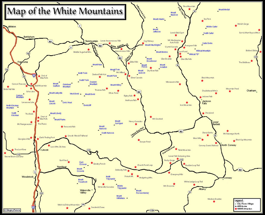
MAP OF THE 4000-FOOTERS
Feel free to save or print this .JPEG map of the 4,000-footers (which are marked in blue). I've also listed many other of the top attractions in the White Mountains with a red star. Take note that Mt. Moosilauke, Mt. Waumbek, and Mt. Cabot are not shown on this map. At some point I hope to update this map to make it larger and include more of the best attractions of the White Mountains.
|