| STATE |
WATERFALL NAME |
SCENIC
POTENTIAL |
TOWN |
NOTES & DESCRIPTION |
| CT |
Bantam Fals |
POOR |
Bantam |
small cascades below a DAM on the Bantam Reservoir; access via Bantam Road near its intersection with Vanderpoel Avenue |
| CT |
Beulah Falls |
unknown |
Colebrook |
this a rumored waterfall on Sandy Brook; supposedly you can bushwhack to the falls from Sandy Brook Road; one website said you can't see the falls from the road itself; there is a strong possibility that this waterfall is located on PRIVATE PROPERTY |
| CT |
Blackberry River Falls |
POOR |
East Canaan |
small cascades below a DAM; also known as Waterfall on Blackberry River |
| CT |
Black Pond Falls |
POOR |
Middlefield |
I visited in 2002 and was extremely disappointed by this 15-foot "waterfall"; lots of trash was found here too; skip this one, although I will admit the view of Black Pond from an outlook further up the trail from the falls is worthwhile; access via 0.2 mile hike from trailhead at Black Pond Road |
| CT |
Cameron Farm Falls |
unknown |
Moodus |
rumored waterfall behind the (now defunct) Cameron Family Farm; you can see some whitewater if you look at Google Maps between the junctions of Neptune Ave, Green Village Street (CT 149) and Moodus Leesville Road; there is a strong possibility that this waterfall is located on PRIVATE PROPERTY; GPS = 41.501060, -72.456091 |
| CT |
Carr Brook Falls |
GOOD |
Portland |
this 10 to 20-foot tall falls on Carr Brook is upstream of the intersection of Rose Hill Road and Cox Road; the falls are almost certainly on PRIVATE PROPERTY; I've driven around this area and I can confirm there is no official trail to the falls, nor can you see the falls from the road; also known as "Graham's Secret"; you can find photos of this waterfall on Justin Coleman's website |
| CT |
Chapman Mill Falls |
POOR |
Westbrook |
this is a DAM at the southern end of Chapmans Pond |
| CT |
Clark Creek Falls |
FAIR |
Haddam |
this small set of cascades is located near the junction of CT 82 and CT 154 (Saybrook Road); I believe the falls should be visible from the road, or perhaps by stepping a few feet into the woods; GPS = 41.443797, -72.472283 |
| CT |
Clarks Falls |
POOR |
North Stonington |
I am fairly confident that this is a small DAM next to the house at 60 Clarks Falls Road at the edge of Spaulding Pond |
| CT |
Coxs Falls |
POOR |
Portland |
looks like a small DAM; you can see the DAM from Rose Hill Road if you zoom in on Google Maps |
| CT |
Devil's Glen |
FAIR |
Weston |
this waterfall may have some potential; the falls are very close to roadside off Valley Forge Road, but I can see a sign on Google Maps that says this area is for town residents only; I will likely try to visit at some point |
| CT |
Diamond Falls Ledge |
FAIR |
West Stafford |
this looks be a small and natural falls; there is a 1908-09 postcard floating around the Internet and that's the only information I have on these falls |
| CT |
East Meadow Brook Falls |
FAIR |
Woodbury |
this rumored waterfall is likely to be on PRIVATE PROPERTY; I believe the falls are located between Flands Road and US-6 |
| CT |
Enfield Falls |
POOR |
Enfield |
I believe this is a small DAM on the Connecticut River; it looks like the DAM can get drowned in high water |
| CT |
Falls in Pequonnock River Valley State Park |
FAIR |
Trumbull |
small cascades in attractive gorge on the Pequonnock River; within Pequonnock River Valley State Park |
| CT |
Falls, The |
POOR |
Fairfield |
this is a small DAM that is visible from Harbor Road looking north |
| CT |
Falls, The |
POOR |
Milford |
this is a DAM near downtown Milford; the DAM is visible from the junction of New Haven Avenue and Daniel Street |
| CT |
Falls, The |
POOR |
Norwalk |
this is a DAM on the Fivemile River at the southern end of Chasmars Pond |
| CT |
Gladdings Falls |
POOR |
Chester |
this is a small DAM on the property of the 'Brushmill by the Waterfall' |
| CT |
Great Falls |
POOR |
New Milford |
this is believed to be a historic and natural waterfall that was completely drowned when a DAM was built downstream |
| CT |
Great Unconformity Falls |
unknown |
Southfield |
this is a rumored waterfall on Roaring Brook; this may or may not be located on PRIVATE PROPERTY; you can see some whitewater on Google Maps a short distance southeast of the New Britain Reservoir; may also be known as Roaring Brook Falls |
| CT |
Greenleaf Falls |
GOOD |
Stamford |
I've seen a postcard that suggests that this is a beautiful waterfall; supposedly located in the "Long Ridge" historic district of Stamford; may or may not be located on PRIVATE PROPERTY |
| CT |
Griswolds Falls |
POOR |
Chester |
this appears to be a DAM on Pattaconk Brook just east of Jennings Pond; the falls should be visible from CT 148 / West Main Street and/or from Spring Street |
| CT |
Higganum Creek Falls |
GOOD |
Haddam |
low-angle fanning cascade on Higganum Creek; may or may not be located on PRIVATE PROPERTY |
| CT |
Horseshoe Falls |
POOR |
Terryville |
this is a DAM; visible from Canal Street looking north |
| CT |
Humaston Brook Falls |
unknown |
Northfield |
rumored waterfall in Humaston Brook State Park, which is an under-developed state park |
| CT |
Jelliff Mill Falls |
POOR |
Stamford |
this a DAM at the southern end of Jelliff Mill Pond; visible from Jelliff Mill Road |
| CT |
John Dees Falls |
POOR |
Waterbury |
this appears to be a DAM on the Mad River; the DAM should be visible from the parking lot of Burlington Coat Factory or from East Main Street |
| CT |
Leesville Falls |
POOR |
East Hampton |
this is a DAM at the edge of Leesville Pond on the Salmon River; you may be able to see the DAM through the trees along CT 151 just south of the junction of CT 151 and CT 196 |
| CT |
Lost Lake Falls |
POOR |
Guilford |
looks unimpressive per ctwaterfalls.com; name is not official |
| CT |
Macedonia Gorge & Falls |
POOR |
Kent |
very small cascades on Macedonia Brook within Macedonia Brook State Park; attractive area but falls are just not that impressive |
| CT |
Middle Falls |
POOR |
Seymouth |
I believe this is a DAM on the Little River a short distance upstream from where the Little River dumps into the Naugatuck River; you may or may not be able to see the DAM from CT 67 (Bank Street), River Street, or by taking a short walk from the Allen's Plumbing Supply parking lot |
| CT |
Mohegan Sun Falls |
POOR |
Uncasville |
perhaps the tallest and prettiest artificial waterfall in Connecticut?; located near the hotel check-in/registration area |
| CT |
Moodus Falls |
FAIR |
Moodus |
I believe this is a natural set of cascades off Falls Road / CT 149 near its junction with Falls Bashan Road; however, it is extremely likely that this is located on PRIVATE PROPERTY with no public access or ability to view the falls |
| CT |
Mount Carmel Spring Falls |
POOR |
Hamden |
looks unimpressive per CT waterfalls; name is not official; I visited and was not impressed |
| CT |
Pequabuck Gorge Falls |
POOR |
Unknown |
cascades below a pretty and curved DAM on the Pequabuck River; also known as "Plymouth Water Control Falls" |
| CT |
Pixie Falls |
FAIR |
Ashford |
chain of small cascades acccessible via a spur trail off the Nipmuck Trail (which is a 35-mile-long path from Mansfield to the Massachusetts border); Boston Hollow Brook; try parking on Iron Mine Road |
| CT |
Pomperaug Falls |
POOR |
Woodbury |
this is a pretty DAM with some cascades below it on the Pomperaug River; the dam and falls are visible from Pomeraug Road off South Pomperaug Avenue; GPS = 41.526490, -73.210512 |
| CT |
Quinebaug Falls |
POOR |
Jewitt City & Griswold |
this is a DAM on the Quinebaug River; the DAM is visible from CT 138 / Slater Avenue |
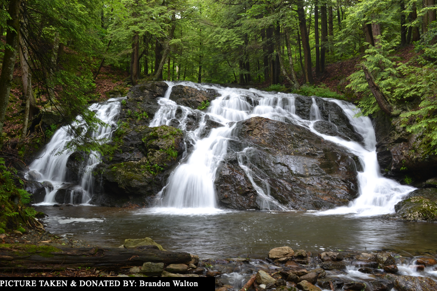
| CT |
Riga Falls
(picture)  |
GOOD |
Salisbury |
is is extremely likely that these falls on Wachocastinook Creek are located on PRIVATE PROPERTY; my research indicates this is a pretty horsetail, and it may also be a swimming hole; hopefully this waterfall gets conserved during our lifetime; also known as "Mt. Riga Falls" |
| CT |
Rippowam Falls |
FAIR |
Unknown |
supposedly “located on the west branch of the Rippowam River under the Route 1 bridge in Stamford" |
| CT |
Roxbury Falls |
POOR |
Roxbury |
this is a series of small cascades on the Shepaug River; the falls can only be visited by residents of the town of Roxbury; access via Minor Bridge Road; also known as "Shepaug Falls" |
| CT |
Shetucket Falls |
POOR |
Norwich & Lisbon |
this is a DAM on the Shetucket River |
| CT |
Silver Falls |
GOOD |
Montville |
I visited in 2002 and found this waterfall on Latimer Brook to be located on PRIVATE PROPERTY!; 11-foot tall falls into deep pool; hopefully this property will be conserved and opened to the public at some point |
| CT |
Succor Brook Falls |
unknown |
East Haddam |
this is a set of (believed to be unimpressive) cascades on Succor Brook; close to the junction of CT 82 and Porges Road; falls should be roadside or very close to it |
| CT |
Tariffville Gorge Cascades |
FAIR |
Tariffville |
rapids and very small cascades on the Farmington River; when I tried to visit in 2017 via CT 189, I ran into PRIVATE PROPERTY; you may be able to see the falls from the nearby Metacomet Trail though |
| CT |
Thayer Brook Cascades |
FAIR |
Kent |
this is a small 6-foot cascade on Thayer Brook; hiking to the falls involves a 1.3 mile mostly uphill hike on the Appalachian Trail followed by a short bushwack |
| CT |
Tunxis Falls |
GOOD |
Winsted |
this is a DAM on the Still River that may or may not have some cascades below it; the whole area is marked as PRIVATE PROPERTY; the DAM is 0.3 miles upstream from the Still River Gorge & Rapids |
| CT |
Unnamed Falls |
unknown |
New Milford |
these appear to be small cascades on the Still River; access may or may not be possible off Lanesville Road just south of Still River Drive; GPS = 41.537621, -73.415521 |
| CT |
Unnamed Falls |
POOR |
New Milford |
this seasonal falls on an unnamed stream is located on PRIVATE PROPERTY near the junction of Lower Grove Street (Grove Street) and Hine Hill Road; you can supposedly see the falls from the road |
| CT |
Unnamed Falls |
unknown |
Winchester |
rumored seasonal falls on unnamed stream; supposedly located very close to Torrington Road south of the section of town known as Winsted |
| CT |
Unnamed Falls |
unknown |
Redding |
rumored falls on the Aspetuck River off Poverty Hill Road less than 0.4 mile south of Church Hill Road; the falls should be roadside or near-roadside |
| CT |
Unnamed Falls |
unknown |
New Hartford |
rumored set of seasonal falls on unnamed stream; access supposedly via a trail at the southern end of Satan's Kingdom Park Road |
| CT |
Unnamed Falls |
unknown |
Winchester |
rumored waterfall near the junction of CT 8, CT 20 and Smith Hill Road in the section of Winchester known as Nelsons Corner; these falls are likely on PRIVATE PROPERTY |
| CT |
Unnamed Falls |
unknown |
North Granby |
this is a rumored waterfall on Belden Brook; it is supposedly located in the Tunxis State Forest off Lost Acres Road near the Granby/Hartland town line. The falls are "less than 0.1 mile from the road where Belden Brook runs over a steep, rocky slope. Though they are close to the road, the approach to them is very steep, trailless and slippery after a rainfall." |
| CT |
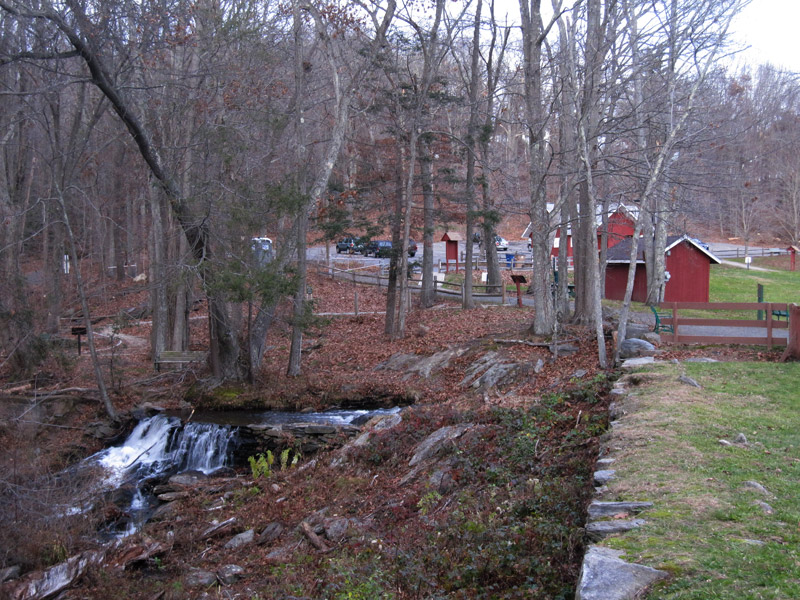
Valley Falls Park
(picture) |
POOR |
Vernon |
despite the name of this little park in Vernon, there is no natural waterfall to be found here; there is a small DAM 150ft from the parking area, but it's just a DAM (and it's a bit ugly); I walked all of Railroad Brook within the park and can 100% confirm there is no natural waterfall here |
| CT |
Wetauwanchu Brook Falls |
FAIR |
Salisbury |
this waterfall on Wetauwanchu Brook is located on PRIVATE PROPERTY, although you can see the falls across the street from the lower parking area of the Great Falls of the Housatonic River |
| CT |
Wolcott Falls |
GOOD |
Hamden |
I visited these falls on Shepard Brook in 2003 and was only slightly impressed; I think I need to pay another visit though; take the Timberwood Trail off of Shepard Avenue down to the 23-foot tall falls; good information can be found here: https://www.hlct.org/properties-2.html |
